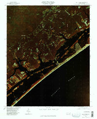
1980 Map of Holly Ridge
USGS Topo · Published 1985About this map
Holly Ridge serves as the inland anchor for this coastal survey, where the terrestrial landscape of Onslow County meets the intricate barrier island systems of the Atlantic coast. This color infrared orthophotograph, captured in late 1980, reveals the distinct boundary between the managed timber and agricultural lands of Edgecombe and the salt-sprayed development of Surf City. The intricate network of tidal waterways, including Topsail Sound and smaller inlets like Mullet Run and Virginia Creek, defines the local geography. Coastal settlements such as Watts Landing and Morris Landing dot the inner shoreline, while Topsail Beach sits at the southern reach of the barrier island. Further inland, the drainage patterns of Batts Mill Creek and Cypress Branch illustrate the slow transition from freshwater swamps to the marine environment.
Find a feature on this map
13 named features on this map. Tap any name to fly to it.
Don’t see what you’re looking for? This feature index may not catch every label — zoom into the map to look around manually.
Map Details
Editions of this 1980 Holly Ridge Map
This is the sole edition of this map. No revisions or reprints were ever made.
Other maps of this area

1942 · Spicer Bay
USGS Topo · 1:62,500

1942 · Topsail
USGS Topo · 1:62,500

1948 · Maple Hill
USGS Topo · 1:62,500

1948 · Topsail
USGS Topo · 1:62,500

1948 · New River
USGS Topo · 1:62,500

1952 · Spicer Bay
USGS Topo · 1:24,000

1952 · Sneads Ferry
USGS Topo · 1:24,000

1953 · Beaufort
USGS Topo · 1:250,000

1954 · Beaufort
USGS Topo · 1:250,000

1970 · Hampstead
USGS Topo · 1:24,000
Featured Places
- Surf City, NC
- Holly Ridge, NC
- North Topsail Beach, NC
- Topsail Beach, NC
- Marine Corps Base Camp Lejeune, NC