
1970 Map of Hampstead
USGS Topo · Published 1972About this map
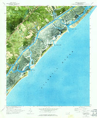
Hampstead sits as the primary inland hub along U S 17, overlooking a complex network of marshes and maritime channels just before the coastal developments of the late 20th century. This orthophotomap provides a clear view of the Pender and New Hanover County line as it cuts through the sound towards Rich Inlet. The landscape is defined by the Intracoastal Waterway and the protective barrier of the Banks, where Topsail Beach and Figure Eight Island are separated by New Topsail Inlet. Inland, small rural settlements like Council and educational landmarks such as Topsail High Sch suggest the area's mid-century growth. Navigational markers and tidal features like Kings Landing and Old Point trace the intricate interface between the mainland and the Topsail Sound.
Find a feature on this map
36 named features on this map. Tap any name to fly to it.
Don’t see what you’re looking for? This feature index may not catch every label — zoom into the map to look around manually.
Map Details
Editions of this 1970 Hampstead Map
2 editions found
Other maps of this area

1942 · Topsail
USGS Topo · 1:62,500

1942 · Wilmington
USGS Topo · 1:62,500

1947 · Rocky Point
USGS Topo · 1:62,500

1948 · Topsail
USGS Topo · 1:62,500

1948 · Wilmington
USGS Topo · 1:62,500

1953 · Beaufort
USGS Topo · 1:250,000

1954 · Beaufort
USGS Topo · 1:250,000
1970 · Wrightsville Beach
USGS Topo · 1:24,000

1970 · Topsail
USGS Topo · 1:24,000

1970 · Scotts Hill
USGS Topo · 1:24,000