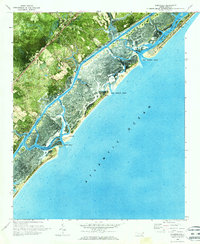
1970 Map of Hampstead
USGS Topo · Published 1973About this map
The coastal village of Hampstead serves as the inland anchor for this 1970 orthophotomap, which vividly captures the barrier island complex of Pender County. The landscape is defined by the intricate networks of Topsail Sound and Middle Sound, where tidal marshlands are carved by deep-water arteries like Nixon Channel and Green Channel. This era shows the developed strip of Topsail Beach before subsequent decades of hurricane activity and shoreline migration significantly reshaped the inlets.
Find a feature on this map
30 named features on this map. Tap any name to fly to it.
Don’t see what you’re looking for? This feature index may not catch every label — zoom into the map to look around manually.
Map Details
Editions of this 1970 Hampstead Map
2 editions found
Other maps of this area

1942 · Topsail
USGS Topo · 1:62,500

1942 · Wilmington
USGS Topo · 1:62,500

1947 · Rocky Point
USGS Topo · 1:62,500

1948 · Topsail
USGS Topo · 1:62,500

1948 · Wilmington
USGS Topo · 1:62,500

1953 · Beaufort
USGS Topo · 1:250,000

1954 · Beaufort
USGS Topo · 1:250,000

1970 · Hampstead
USGS Topo · 1:24,000
1970 · Wrightsville Beach
USGS Topo · 1:24,000

1970 · Topsail
USGS Topo · 1:24,000