1980s Maps of Polk County, North Carolina
Explore 10 historic maps of Polk County from the 1980s. These maps offer a rare glimpse into what life looked like during the 1980s — showing old roads, neighborhoods, homes, and landmarks that have changed or disappeared over time.
Whether you're researching your family's past, planning a metal detecting trip, or studying how Polk County's landscape evolved across the 1980s, these high-resolution maps are a powerful tool for exploring the history of this region.
- Focus on a specific era: All maps on this page are from the 1980s, giving you a focused view of this time period.
- See what’s changed: Compare century-old streets, trails, and buildings to today's modern landscape using overlays and satellite layers.
- Research with precision: Use these maps for genealogy, historical research, land use analysis, or educational projects.
- View, download, or print: Maps are fully viewable online in high resolution, and can be downloaded or printed for your own records.
Start exploring Polk County's history through authentic maps from the 1980s. This is your window into the past.
Polk County, NC maps
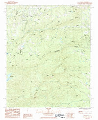
(10)- 1982 Map of Pea Ridge, 1983 Print
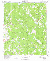 1982 Pea Ridge1983 Print · USGSThe river valleys of Polk and Rutherford counties are captured here in the early eighties. Genealogists can trace family landmarks and rural congregations like Pea Ridge, Byars Cem, and Zion Grove Ch along the Green River.
 - 1982 Map of Lake Lure, 1983 Print
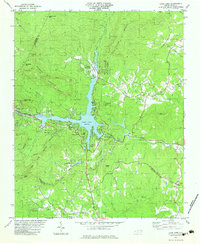 1982 Lake Lure1983 Print · USGSThe Hickory Nut Gorge area near the start of the 1980s reveals a landscape of high peaks and deep waters centered on Lake Lure. Genealogists and historians can locate rural landmarks like St Johns Ch, Cooper Gap Ch, and the small settlement at Uree.3 unique versions available
 - 1982 Map of Shingle Hollow, 1983 Print
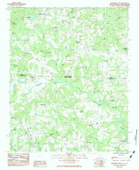
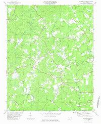 1982 Shingle Hollow1983 Print · USGSRutherford County in the early 1980s is shown here as a landscape of rural congregations and river bends. Genealogists can locate family landmarks like Mathews Ch, Mtn Creek Cem, and the community of Shingle Hollow.
 - 1982 Map of Mill Spring, 1983 Print
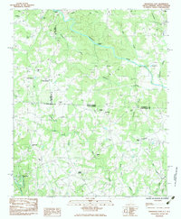
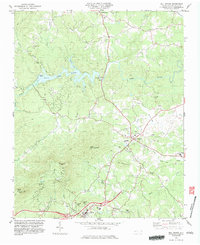 1982 Mill Spring1983 Print · USGSPolk County at the start of the 1980s reveals a landscape defined by the waters of Lake Adger and the foothills of the Blue Ridge. Genealogists and local historians can trace rural family churches like Victory Ch and landmarks such as Red Barn Landing or Tryon Peak.2 unique versions available
 - 1983 Map of Fingerville East
 1983 Fingerville East1983 Print · USGSThe borderlands of the Carolinas in the early 1980s show a rural network of small crossroads and river crossings. Genealogists and local historians can trace family roots through numerous sites like Alverson Grove Ch, Brooklyn Cem, and the settlement of Fingerville.
 - 1983 Map of Saluda
 1983 Saluda1983 Print · USGSCrossing the Blue Ridge escarpment in the 1980s, this area shows the historic rail and mountain corridor between North and South Carolina. Genealogists can trace local landmarks like Friendship Ch, Mountain Hill Ch, and the high peak of Glassy Mountain.2 unique versions available
 - 1983 Map of Fingerville West
 1983 Fingerville West1983 Print · USGSThe Carolina borderlands come alive in this early 1980s survey of the Spartanburg and Polk County area. Researchers can trace rural lineages through local landmarks like Little Africa, New Prospect, and historic congregations such as Melvin Hill Ch.
 - 1983 Map of Landrum
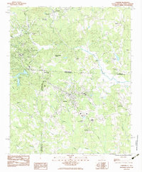 1983 Landrum1983 Print · USGSThe foothills of the Carolinas come alive in this early 1980s survey of the borderlands between North and South Carolina. Trace the rail-and-road corridor through Landrum and Tryon, or locate family landmarks like Fellowship Ch, Oak Grove Ch, and Burnt Chimney Corner.
 - 1986 Map of Hendersonville
 1986 Hendersonville1986 Print · USGSThe Blue Ridge foothills of North and South Carolina are documented here in the mid-eighties as modern highways began to reshape mountain travel. Local historians can trace the paths of the Southern Railway through Hendersonville or locate landmarks like Looking Glass Rock and Inman Mills.2 unique versions available
 - 1986 Map of Gastonia
 1986 Gastonia1986 Print · USGSThe Carolina Piedmont in the mid-eighties shows a landscape shaped by Revolutionary War history and the textile industry. Trace the footprints of early battles at Kings Mountain National Military Park and locate depots along the Southern Railway in Shelby and Gastonia.
End of results
Showing maps 1-10 of 10
Top cities of Polk County
Frequently asked questions
- What are the different types of historical maps available for Polk County?
- What is the oldest map of Polk County?
- Where can I purchase historical maps of Polk County for my home or office?
- Where can I download high-res historical maps of Polk County?
- Are there historical topographic maps available for Polk County?
- Is there historical aerial imagery available for Polk County?
- Where are historical maps of Polk County sourced from?