1940s Maps of Polk County, North Carolina
Explore 4 historic maps of Polk County from the 1940s. These maps offer a rare glimpse into what life looked like during the 1940s — showing old roads, neighborhoods, homes, and landmarks that have changed or disappeared over time.
Whether you're researching your family's past, planning a metal detecting trip, or studying how Polk County's landscape evolved across the 1940s, these high-resolution maps are a powerful tool for exploring the history of this region.
- Focus on a specific era: All maps on this page are from the 1940s, giving you a focused view of this time period.
- See what’s changed: Compare century-old streets, trails, and buildings to today's modern landscape using overlays and satellite layers.
- Research with precision: Use these maps for genealogy, historical research, land use analysis, or educational projects.
- View, download, or print: Maps are fully viewable online in high resolution, and can be downloaded or printed for your own records.
Start exploring Polk County's history through authentic maps from the 1940s. This is your window into the past.
Polk County, NC maps
(4)- 1946 Map of Bat Cave, 1957 Print
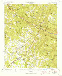 1946 Bat Cave1957 Print · USGSHenderson County in the 1940s reveals a network of mountain communities and remote creek valleys. Genealogists and historians can trace family locations near Maxwell Mill, Edneyville Cem, and numerous country churches like Mt Moriah Ch.6 unique versions available
 - 1946 Map of Cliffield Mtn, 1957 Print
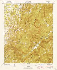 1946 Cliffield Mtn1957 Print · USGSHenderson and Polk counties appear here just after the war, showing a landscape of high mountain ridges and river gorges. Researchers can trace family history through several rural burial grounds like Jones Cem and Bradley Cem, or locate landmarks like Bradley Falls.4 unique versions available
 - 1947 Map of Bat Cave
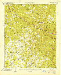 1947 Bat Cave1947 Print · USGSHenderson County's mountain communities and river valleys are captured here just after the war. Researchers can locate family landmarks like Edneyville Cem, rural institutions such as St Peters Sch, and local hubs like Gerton.2 unique versions available
 - 1947 Map of Cliffield Mtn.
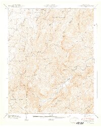 1947 Cliffield Mtn.1947 Print · USGSHenderson and Polk counties appear in the late 1940s, showing a landscape defined by the Blue Ridge and high peaks. Genealogists can trace family names at Jones-Price Cem and Bradley Cem or locate the site of the old Dana Sch.2 unique versions available
End of results
Showing maps 1-4 of 4
Top cities of Polk County
Frequently asked questions
- What are the different types of historical maps available for Polk County?
- What is the oldest map of Polk County?
- Where can I purchase historical maps of Polk County for my home or office?
- Where can I download high-res historical maps of Polk County?
- Are there historical topographic maps available for Polk County?
- Is there historical aerial imagery available for Polk County?
- Where are historical maps of Polk County sourced from?