1990s Maps of Rockingham County, North Carolina
Explore 6 historic maps of Rockingham County from the 1990s. These maps offer a rare glimpse into what life looked like during the 1990s — showing old roads, neighborhoods, homes, and landmarks that have changed or disappeared over time.
Whether you're researching your family's past, planning a metal detecting trip, or studying how Rockingham County's landscape evolved across the 1990s, these high-resolution maps are a powerful tool for exploring the history of this region.
- Focus on a specific era: All maps on this page are from the 1990s, giving you a focused view of this time period.
- See what’s changed: Compare century-old streets, trails, and buildings to today's modern landscape using overlays and satellite layers.
- Research with precision: Use these maps for genealogy, historical research, land use analysis, or educational projects.
- View, download, or print: Maps are fully viewable online in high resolution, and can be downloaded or printed for your own records.
Start exploring Rockingham County's history through authentic maps from the 1990s. This is your window into the past.
Rockingham County, NC maps
(6)- 1996 Map of Ayersville, 2001 Print
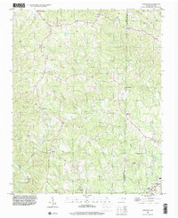 1996 Ayersville2001 Print · USGSStokes and Rockingham Counties are shown in the mid-1990s as a landscape of rural crossroads and river-valley settlements. Researchers can trace family history through local landmarks like Mt Hermon Ch, Prestonville, and the small community of Dodgetown.
 - 1997 Map of Williamsburg, 2000 Print
 1997 Williamsburg2000 Print · USGSThe Piedmont landscape of Rockingham and Caswell Counties in the late nineties is detailed here through its rural settlements and river networks. Genealogists can trace family landmarks like Settle Cem and Garrett Grove Ch along the Haw River.
 - 1997 Map of Mayodan, 2000 Print
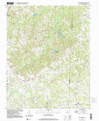
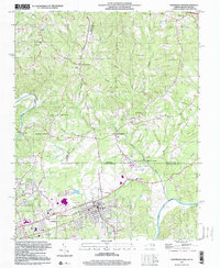
 1997 Mayodan2000 Print · USGSMayodan and Madison sit at the historic confluence of the Mayo and Dan Rivers in the late nineties. Genealogists and local historians can trace family sites at Llewellyn Cem and Glens Chapel or locate the old Norfolk and Western rail corridor.
 - 1997 Map of Bethany, 2000 Print
 1997 Bethany2000 Print · USGSThe rural landscape of Rockingham and Guilford counties is preserved here in the late 1990s, centered on several local junctions. Family historians and researchers can trace longstanding community anchors like Wittys Crossroads, Bethany, and Howards Chapel Cem.
 - 1997 Map of Ellisboro, 2000 Print
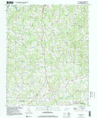 1997 Ellisboro2000 Print · USGSSouthern Rockingham County in the late 1990s is captured here, showing the rural communities of Ellisboro and Intelligence near the Dan River. Genealogists can locate numerous landmarks including Kallam Grove Ch, Gideon Ch, and Woodland Cem.
 - 1997 Map of Northeast Eden, 2000 Print
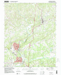
 1997 Northeast Eden2000 Print · USGSThe North Carolina-Virginia border comes alive in the late 1990s as the industrial hubs of Draper and Spray sit near the confluence of the Dan River. Genealogists and historians can trace rail lines like the Norfolk and Western or locate rural landmarks such as Irisburg Sch and St Johns Ch.
End of results
Showing maps 1-6 of 6
Top cities of Rockingham County
- Eden historical maps
- Reidsville historical maps
- Wentworth historical maps
- Mayodan historical maps
- Madison historical maps
- Stoneville historical maps
Frequently asked questions
- What are the different types of historical maps available for Rockingham County?
- What is the oldest map of Rockingham County?
- Where can I purchase historical maps of Rockingham County for my home or office?
- Where can I download high-res historical maps of Rockingham County?
- Are there historical topographic maps available for Rockingham County?
- Is there historical aerial imagery available for Rockingham County?
- Where are historical maps of Rockingham County sourced from?