2000-2009 Maps of Scotland County, North Carolina
Explore 3 historic maps of Scotland County from 2000-2009. These maps offer a rare glimpse into what life looked like during the 2000s — showing old roads, neighborhoods, homes, and landmarks that have changed or disappeared over time.
Whether you're researching your family's past, planning a metal detecting trip, or studying how Scotland County's landscape evolved across the 2000s, these high-resolution maps are a powerful tool for exploring the history of this region.
- Focus on a specific era: All maps on this page are from the 2000s, giving you a focused view of this time period.
- See what’s changed: Compare century-old streets, trails, and buildings to today's modern landscape using overlays and satellite layers.
- Research with precision: Use these maps for genealogy, historical research, land use analysis, or educational projects.
- View, download, or print: Maps are fully viewable online in high resolution, and can be downloaded or printed for your own records.
Start exploring Scotland County's history through authentic maps from the 2000s. This is your window into the past.
Scotland County, NC maps
(3)- 2002 Map of Hoffman
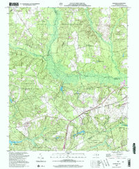 2002 Hoffman2002 Print · USGSHoffman and the surrounding pine forests are captured here at the start of the millennium, showing a landscape defined by military training and wildlife conservation. Researchers can locate Watson Cem, rural churches like McNir Chapel, and the vast Camp Mackall Military Reservation.
 - 2002 Map of Wagram
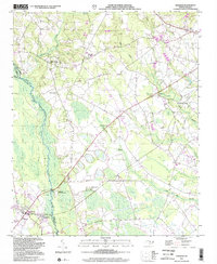 2002 Wagram2002 Print · USGSThe Lumber River lowlands of Scotland and Hoke Counties are captured here at the dawn of the millennium. Researchers can trace the path of the Laurinburg and Southern RR and locate rural landmarks like Purcell Cem and Shady Grove Ch.
 - 2002 Map of Pinebluff
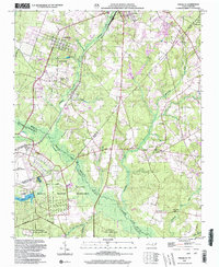 2002 Pinebluff2002 Print · USGSMoore County at the start of the millennium shows a fascinating mix of established town life and large-scale military landscapes. Researchers can trace local heritage at Poplar Springs Church, identify the rail-side Ice Loading Platform, or locate family sites near Silver Springs.
End of results
Showing maps 1-3 of 3
Top cities of Scotland County
- Laurinburg historical maps
- Laurel Hill historical maps
- Wagram historical maps
- Gibson historical maps
- East Laurinburg historical maps
- Old Hundred historical maps
Frequently asked questions
- What are the different types of historical maps available for Scotland County?
- What is the oldest map of Scotland County?
- Where can I purchase historical maps of Scotland County for my home or office?
- Where can I download high-res historical maps of Scotland County?
- Are there historical topographic maps available for Scotland County?
- Is there historical aerial imagery available for Scotland County?
- Where are historical maps of Scotland County sourced from?