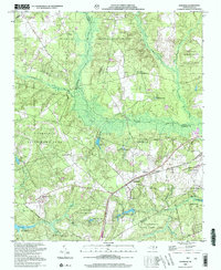
2002 Map of Hoffman
USGS Topo · Published 2002About this map
Hoffman serves as the central hub of this Sandhills landscape, where the confluence of Richmond, Moore, and Scotland counties meets a significant conservation and military corridor. Much of the terrain is defined by the Sandhills State Game Land, a protected expanse that preserves the longleaf pine ecosystem and natural drainage of Drowning Creek and Naked Creek. The southeastern corner transitions into the Camp Mackall Military Reservation, featuring an Auxiliary Airfield and the High Sch near the town center. For those tracing local history, several rural houses of worship are distributed across the ridges, including Taylor Memorial Ch near Narrow Ridge and the isolated Deer Grove Ch. The presence of the Mc Kinney Lake State Fish Hatchery and Morrison Training Sch highlights the state's institutional land use in the mid-20th century.
Find a feature on this map
39 named features on this map. Tap any name to fly to it.
Don’t see what you’re looking for? This feature index may not catch every label — zoom into the map to look around manually.
Map Details
Editions of this 2002 Hoffman Map
This is the sole edition of this map. No revisions or reprints were ever made.
Other maps of this area

1942 · Troy
USGS Topo · 1:125,000

1942 · Rockingham
USGS Topo · 1:125,000

1948 · Southern Pines
USGS Topo · 1:62,500

1948 · Pinebluff
USGS Topo · 1:24,000

1949 · Millstone Lake
USGS Topo · 1:24,000

1949 · Silver Hill
USGS Topo · 1:24,000

1949 · West End
USGS Topo · 1:24,000

1949 · Hoffman
USGS Topo · 1:24,000

1949 · Marston
USGS Topo · 1:24,000

1949 · Hamlet
USGS Topo · 1:24,000