1970s Maps of Norwood, North Carolina
Explore 2 historic maps of Norwood from the 1970s. These maps offer a rare glimpse into what life looked like during the 1970s — showing old roads, neighborhoods, homes, and landmarks that have changed or disappeared over time.
Whether you're researching your family's past, planning a metal detecting trip, or studying how Norwood's landscape evolved across the 1970s, these high-resolution maps are a powerful tool for exploring the history of this region.
- Focus on a specific era: All maps on this page are from the 1970s, giving you a focused view of this time period.
- See what’s changed: Compare century-old streets, trails, and buildings to today's modern landscape using overlays and satellite layers.
- Research with precision: Use these maps for genealogy, historical research, land use analysis, or educational projects.
- View, download, or print: Maps are fully viewable online in high resolution, and can be downloaded or printed for your own records.
Start exploring Norwood's history through authentic maps from the 1970s. This is your window into the past.
Norwood, NC maps
(2)- 1971 Map of Aquadale, 1973 Print
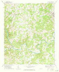 1971 Aquadale1973 Print · USGSThe rural borderlands of Stanly and Anson Counties are revealed in this early 1970s survey of the Carolina Piedmont. Researchers can trace local genealogy through numerous landmarks including South Stanly High School, Bethlehem Ch, and the rail junction at Norwood.2 unique versions available
 - 1977 Map of Albemarle SE, 1979 Print
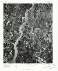 1977 Albemarle SE1979 Print · USGSThe Montgomery County riverfront was evolving in the late seventies as residential life centered on the water. Researchers can trace the exact 1977 shoreline of Lake Tillery and find local settlements like River Haven and Pee Dee.
End of results
Showing maps 1-2 of 2
Top cities near Norwood
- Albemarle historical maps
- Troy historical maps
- Polkton historical maps
- Mount Gilead historical maps
- Badin historical maps
- Oakboro historical maps
See more
Top neighborhoods of Norwood
Frequently asked questions
- What are the different types of historical maps available for Norwood?
- What is the oldest map of Norwood?
- Where can I purchase historical maps of Norwood for my home or office?
- Where can I download high-res historical maps of Norwood?
- Are there historical topographic maps available for Norwood?
- Is there historical aerial imagery available for Norwood?
- Where are historical maps of Norwood sourced from?