1900s (20th Century) Maps of Indian Grove, North Carolina
Explore 7 historic maps of Indian Grove from the 1900s (20th Century). These maps offer a rare glimpse into what life looked like during the 1900s — showing old roads, neighborhoods, homes, and landmarks that have changed or disappeared over time.
Whether you're researching your family's past, planning a metal detecting trip, or studying how Indian Grove's landscape evolved across the 1900s, these high-resolution maps are a powerful tool for exploring the history of this region.
- Focus on a specific era: All maps on this page are from the 1900s, giving you a focused view of this time period.
- See what’s changed: Compare century-old streets, trails, and buildings to today's modern landscape using overlays and satellite layers.
- Research with precision: Use these maps for genealogy, historical research, land use analysis, or educational projects.
- View, download, or print: Maps are fully viewable online in high resolution, and can be downloaded or printed for your own records.
Start exploring Indian Grove's history through authentic maps from the 1900s. This is your window into the past.
Indian Grove, NC maps
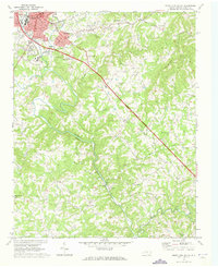
(7)- 1953 Map of Winston-Salem, 1974 Print
 1953 Winston-Salem1974 Print · USGSThe North Carolina Piedmont and Virginia highlands meet in the mid-1950s, a landscape defined by the tobacco and textile hubs of the Blue Ridge foothills. Researchers can trace the rail-and-river geography connecting Winston-Salem to mountain towns like Mount Airy and Galax.2 unique versions available
 - 1955 Map of Winston-Salem
 1955 Winston-Salem1955 Print · USGSThe Central Blue Ridge and Piedmont transition are captured here in the mid-fifties, from the industrial hub of Winston-Salem to the high peaks of Southwest Virginia. Genealogists can trace family landmarks like Richmond Hill Ch, Siloam Ch, and the old rail stops along the Southern Railway.
 - 1962 Map of Winston-Salem
 1962 Winston-Salem1962 Print · USGSThe North Carolina Piedmont meets the Virginia highlands in the early sixties, showing the rail corridors and mountain gaps of the southern Appalachians. Researchers can trace the Blue Ridge Parkway or locate family sites near Winston-Salem, Mount Airy, and Hanging Rock Mountain.
 - 1970 Map of Mount Airy South, 1973 Print
 1970 Mount Airy South1973 Print · USGSThe area south of Mount Airy comes alive in this 1970s survey, showing the expansion of settlements like Bannertown and Toast along the Ararat River. Genealogists and historians can trace numerous country landmarks, including Black Water Cem, Ash Hill, and Whitakers Chapel.2 unique versions available
 - 1976 Map of Mount Airy South, 1979 Print
 1976 Mount Airy South1979 Print · USGSSurry County communities south of the Virginia border appear in high-altitude detail during the mid-seventies. Researchers can trace the development of residential clusters like Bannertown and Toast along the winding course of the Ararat River.
 - 1984 Map of Winston-Salem, 1985 Print
 1984 Winston-Salem1985 Print · USGSThe North Carolina Piedmont in the mid-1980s shows the growth of Winston-Salem and the busy rail corridors of the Southern Railway. Genealogists and local historians can trace family-named lands and rural communities from Yadkinville to Mount Airy.2 unique versions available
 - 1996 Map of Mount Airy South, 2000 Print
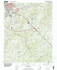 1996 Mount Airy South2000 Print · USGSSurry County experiences significant growth in the mid-1990s as new highway corridors are carved through the Ararat River valley. Genealogists can locate family landmarks at Whitakers Chapel, Boones Hill, and several country cemeteries.
End of results
Showing maps 1-7 of 7
Top cities near Indian Grove
- Mount Airy historical maps
- Dobson historical maps
- Pilot Mountain historical maps
- Cana historical maps
- Fancy Gap historical maps
Frequently asked questions
- What are the different types of historical maps available for Indian Grove?
- What is the oldest map of Indian Grove?
- Where can I purchase historical maps of Indian Grove for my home or office?
- Where can I download high-res historical maps of Indian Grove?
- Are there historical topographic maps available for Indian Grove?
- Is there historical aerial imagery available for Indian Grove?
- Where are historical maps of Indian Grove sourced from?