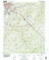
1996 Map of Mount Airy South
USGS Topo · Published 2000About this map
The Ararat River flows southward through this corner of Surry County, carving a path through the foothills as transportation networks evolved in the late twentieth century. Highlighting the region's modernization, new highway infrastructure is marked as Under Construction, diverging from established routes that connect Mount Airy and Bannertown. The map documents a high density of rural religious life, with numerous landmarks like Sulphur Springs Ch, Grace Ch, and Little Mountain Ch serving as focal points for local communities. Aviation and industrial needs are evident at the Mt Airy-Surry Co Airport and the large Quarry operation near Stewarts Creek. From the heights of Chestnut Ridge to the bottomlands along Toms Creek, the landscape reflects a balance of traditional settlements and expanding municipal services.
Find a feature on this map
45 named features on this map. Tap any name to fly to it.
Don’t see what you’re looking for? This feature index may not catch every label — zoom into the map to look around manually.
Map Details
Editions of this 1996 Mount Airy South Map
This is the sole edition of this map. No revisions or reprints were ever made.
Other maps of this area

1889 · Hillsville
USGS Topo · 1:125,000

1891 · Yadkinville
USGS Topo · 1:125,000

1892 · Hillsville
USGS Topo · 1:125,000

1893 · Yadkinville
USGS Topo · 1:125,000

1896 · Hillsville
USGS Topo · 1:125,000

1928 · Stuart
USGS Topo · 1:48,000

1931 · Stuart
USGS Topo · 1:62,500

1953 · Winston-Salem
USGS Topo · 1:250,000

1955 · Winston-Salem
USGS Topo · 1:250,000

1957 · Mount Airy
USGS Topo · 1:62,500