1990s Maps of Transylvania County, North Carolina
Explore 13 historic maps of Transylvania County from the 1990s. These maps offer a rare glimpse into what life looked like during the 1990s — showing old roads, neighborhoods, homes, and landmarks that have changed or disappeared over time.
Whether you're researching your family's past, planning a metal detecting trip, or studying how Transylvania County's landscape evolved across the 1990s, these high-resolution maps are a powerful tool for exploring the history of this region.
- Focus on a specific era: All maps on this page are from the 1990s, giving you a focused view of this time period.
- See what’s changed: Compare century-old streets, trails, and buildings to today's modern landscape using overlays and satellite layers.
- Research with precision: Use these maps for genealogy, historical research, land use analysis, or educational projects.
- View, download, or print: Maps are fully viewable online in high resolution, and can be downloaded or printed for your own records.
Start exploring Transylvania County's history through authentic maps from the 1990s. This is your window into the past.
Transylvania County, NC maps
(13)- 1997 Map of Sam Knob, 2001 Print
 1997 Sam Knob2001 Print · USGSHigh-altitude ridges and wilderness areas dominate this portion of the Blue Ridge in the late twentieth century. Hikers and historians can trace the Blue Ridge Parkway as it bypasses Richland Balsam and find landmarks like Courthouse Falls and Devils Courthouse.
 - 1997 Map of Rosman, 2001 Print
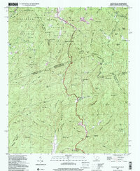
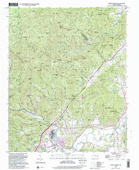
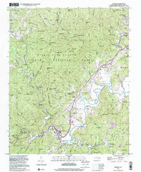 1997 Rosman2001 Print · USGSThe French Broad River valley near the turn of the millennium remains a landscape of mountain ridges and secluded camps. Genealogists and local historians can trace legacy sites like Shady Grove Cem, Zion Ch, and the old NASA Tracking Station.
 - 1997 Map of Cruso, 2001 Print
 1997 Cruso2001 Print · USGSThe East Fork of the Pigeon River valley in the late 1990s remained a landscape of tight-knit mountain coves and significant wilderness peaks. Researchers can trace family history through sites like Longs Chapel, Gudger Cem, and Burnett Cove Ch located beneath the shadows of Cold Mountain.
 - 1997 Map of Cashiers, 2001 Print
 1997 Cashiers2001 Print · USGSThe Blue Ridge high country near the turn of the millennium shows a landscape of deep family roots and protected wilderness. Genealogists can trace local history through sites like Upper Zachary Cem, Heady Mountain Ch, and the settlement at Bohaynee.
 - 1997 Map of Brevard, 2001 Print
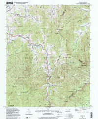
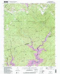
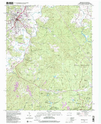 1997 Brevard2001 Print · USGSBrevard and the surrounding Transylvania County highlands are shown here at the turn of the millennium as the area balanced forest preservation with residential growth. Researchers can trace historic family names and community centers through labels like Glazener Cem, Rosenwald School, and Little River Chapel.
 - 1997 Map of Shining Rock, 2001 Print
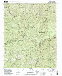
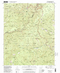 1997 Shining Rock2001 Print · USGSThe high peaks of the Blue Ridge south of Asheville are captured here in the late 1990s, showcasing a landscape of protected wilderness and national forest. Trace the locations of the old Silvermine, the Fish Rearing Station, and the Pilot Mtn Lookout Tower.
 - 1997 Map of Eastatoe Gap, 2001 Print
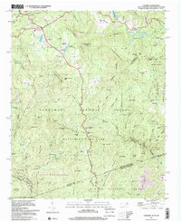
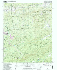
 1997 Eastatoe Gap2001 Print · USGSTransylvania County's mountain passes and mid-century topography are detailed here in the late nineties, documenting the area's transition into the modern era. Trace the path of the Blue Ridge Parkway or locate local landmarks like Camp Adger and Chimneytop.
 - 1997 Map of Horse Shoe, 2001 Print
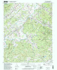 1997 Horse Shoe2001 Print · USGSHenderson County's river-bottom lands and mountain ridges are shown here in the late nineties, centered on the French Broad River. Genealogists can trace family sites like Fletcher Cem and Oak Forest Cem or visit Etowah and Horse Shoe.
 - 1997 Map of Reid, 2001 Print
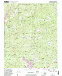
 1997 Reid2001 Print · USGSThe Blue Ridge high country is captured here in the late nineties, documenting the rugged borderlands between North and South Carolina. Researchers can trace family sites near Oakland, find the Oakland Cem, and locate landmarks like Toxaway Falls.
 - 1997 Map of Standingstone Mtn, 2001 Print
 1997 Standingstone Mtn2001 Print · USGSThe Carolina borderlands are defined by water and woods in the late nineties, where the Blue Ridge begins its steep descent. Trace the path of the Little Little River through landmarks like Bridal Veil Falls and Wabak Camp.
 - 1997 Map of Dunsmore Mountain, 2001 Print
 1997 Dunsmore Mountain2001 Print · USGSThe high ridges and deep gaps of the Blue Ridge south of Asheville are shown here in the late twentieth century. Genealogists and hikers can trace old mountain congregations at Mt Pisgah Church or find historic burial sites like Stony Fork Cem and Stuart Cem.
 - 1997 Map of Pisgah Forest, 2001 Print
 1997 Pisgah Forest2001 Print · USGSThe Brevard area and the headwaters of the French Broad River are captured here in the late twentieth century. Genealogists can trace family names at the McCall Cem and Davidson River Cem or locate centers like Cherry Village and the Penrose Sch.
 - 1997 Map of Lake Toxaway, 2001 Print
 1997 Lake Toxaway2001 Print · USGSThe high country of Transylvania and Jackson counties is captured here in the late twentieth century, centered on the waters of Lake Toxaway. Researchers can trace old family sites and mountain congregations at Wolf Mountain Ch, Owens Cem, and the settlement of Quebec.
End of results
Showing maps 1-13 of 13
Top cities of Transylvania County
Frequently asked questions
- What are the different types of historical maps available for Transylvania County?
- What is the oldest map of Transylvania County?
- Where can I purchase historical maps of Transylvania County for my home or office?
- Where can I download high-res historical maps of Transylvania County?
- Are there historical topographic maps available for Transylvania County?
- Is there historical aerial imagery available for Transylvania County?
- Where are historical maps of Transylvania County sourced from?