1990s Maps of Wilkes County, North Carolina
Explore 8 historic maps of Wilkes County from the 1990s. These maps offer a rare glimpse into what life looked like during the 1990s — showing old roads, neighborhoods, homes, and landmarks that have changed or disappeared over time.
Whether you're researching your family's past, planning a metal detecting trip, or studying how Wilkes County's landscape evolved across the 1990s, these high-resolution maps are a powerful tool for exploring the history of this region.
- Focus on a specific era: All maps on this page are from the 1990s, giving you a focused view of this time period.
- See what’s changed: Compare century-old streets, trails, and buildings to today's modern landscape using overlays and satellite layers.
- Research with precision: Use these maps for genealogy, historical research, land use analysis, or educational projects.
- View, download, or print: Maps are fully viewable online in high resolution, and can be downloaded or printed for your own records.
Start exploring Wilkes County's history through authentic maps from the 1990s. This is your window into the past.
Wilkes County, NC maps
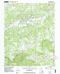
(8)- 1994 Map of Buffalo Cove, 1998 Print
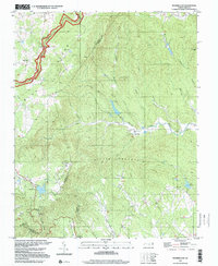
 1994 Buffalo Cove1998 Print · USGSThe Blue Ridge foothills near the Caldwell and Wilkes county line come alive in this mid-nineties survey. Genealogists can trace family names and sites through the Patterson School, Bethany Church, and the Chapel of Rest.
 - 1996 Map of Elkin South, 2000 Print
 1996 Elkin South2000 Print · USGSThe riverfront towns of Jonesville and Elkin meet at the Yadkin River in the mid-1990s, where the rising peaks of the Brushy Mountains define the rural landscape. Genealogists can locate family landmarks like Mountain Grove Ch Cem, Starmount High Sch, and the small airfield at Swan Creek Airport.
 - 1997 Map of Ellendale, 2000 Print
 1997 Ellendale2000 Print · USGSAlexander County comes into focus in the late nineties, showing the intersection of mountain terrain and rural community life. Genealogists and historians can locate family landmarks like Oxford Memorial Ch, the mineral-named All Healing Springs, and Antioch Ch along the Middle Little River.
 - 1997 Map of Roaring Gap, 2000 Print
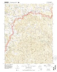
 1997 Roaring Gap2000 Print · USGSThe rural borderlands of Surry, Wilkes, and Alleghany counties are captured here in the late twentieth century as the mountain landscape transitions toward the Piedmont. Researchers can trace family sites at Thompson Cem and Walker Cem, or locate historic congregations like Antioch Ch and Union Hill Ch.
 - 1997 Map of Ronda, 2000 Print
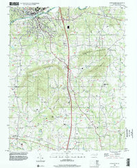
 1997 Ronda2000 Print · USGSThe Yadkin River valley in the late 1990s is captured here, showing the communities of Ronda and Roaring River amidst the southern ridges. Researchers can trace local roots through numerous landmarks like Brier Creek Cem, Poplar Springs Ch, and East Wilkes High Sch.
 - 1997 Map of Osbornville, 2000 Print
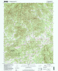
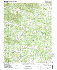 1997 Osbornville2000 Print · USGSOsbornville and the eastern Brushy Mountains are shown at the end of the century as a network of crossroads communities and highland farms. Genealogists can trace family footprints near Smyrna Chapel, Somers Crossroads, and the rural homes surrounding New Hope.
 - 1998 Map of Deep Gap, 1999 Print
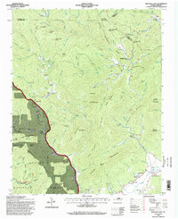
 1998 Deep Gap1999 Print · USGSThe Blue Ridge highlands in the late 1990s are mapped here as the Blue Ridge Parkway snakes through Watauga and Wilkes counties. Researchers can locate remote mountain communities like Triplett, Laxon, and Rutherwood, alongside landmarks such as Holy Trinity Chapel and Parkway Sch.
 - 1998 Map of Whitehead, 1999 Print
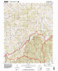 1998 Whitehead1999 Print · USGSNorth Carolina's high ridges and river valleys are captured here in the late nineties as the Blue Ridge Parkway winds through ALLEGHANY CO. Genealogists and local historians can trace family-named sites like Brinegar Cabin, Antioch Cem, and Piney Fork Ch.
End of results
Showing maps 1-8 of 8
Top cities of Wilkes County
Frequently asked questions
- What are the different types of historical maps available for Wilkes County?
- What is the oldest map of Wilkes County?
- Where can I purchase historical maps of Wilkes County for my home or office?
- Where can I download high-res historical maps of Wilkes County?
- Are there historical topographic maps available for Wilkes County?
- Is there historical aerial imagery available for Wilkes County?
- Where are historical maps of Wilkes County sourced from?