1980s Maps of Adams County, North Dakota
Explore 4 historic maps of Adams County from the 1980s. These maps offer a rare glimpse into what life looked like during the 1980s — showing old roads, neighborhoods, homes, and landmarks that have changed or disappeared over time.
Whether you're researching your family's past, planning a metal detecting trip, or studying how Adams County's landscape evolved across the 1980s, these high-resolution maps are a powerful tool for exploring the history of this region.
- Focus on a specific era: All maps on this page are from the 1980s, giving you a focused view of this time period.
- See what’s changed: Compare century-old streets, trails, and buildings to today's modern landscape using overlays and satellite layers.
- Research with precision: Use these maps for genealogy, historical research, land use analysis, or educational projects.
- View, download, or print: Maps are fully viewable online in high resolution, and can be downloaded or printed for your own records.
Start exploring Adams County's history through authentic maps from the 1980s. This is your window into the past.
Adams County, ND maps
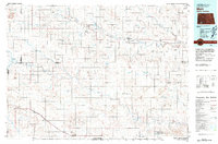
(4)- 1980 Map of Elgin
 1980 Elgin1980 Print · USGSNorth Dakota's southern plains come alive in the early eighties as the Standing Rock Indian Reservation meets the Cannonball River. Trace the rail lines serving Elgin and Carson, or locate family-named landmarks like Thompson Butte and Heil.
 - 1980 Map of McIntosh, 1981 Print
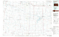
 1980 McIntosh1981 Print · USGSThe northern plains of the Standing Rock Indian Reservation are shown here as they appeared in the early 1980s. You can trace the railroad history of Corson County along the Chicago Milwaukee St Paul and Pacific line, connecting settlements like Watauga and Morristown.
 - 1980 Map of Mott, 1981 Print
 1980 Mott1981 Print · USGSThe North Dakota plains around the turn of the 1980s reveal a landscape of river-valley farming and critical rail connections. Researchers can trace the path of the Milwaukee Road through Bucyrus or locate landmarks like East Rainy Butte and Tepee Buttes.
 - 1984 Map of Lemmon
 1984 Lemmon1984 Print · USGSThe High Plains borderlands of South Dakota and North Dakota are documented here in the mid-1980s, centered on the Lemmon and Hettinger rail corridor. Genealogists and historians can trace local landmarks like Strool, the Shadehill Reservoir shoreline, and isolated buttes including White Butte and Square Top Butte.2 unique versions available
End of results
Showing maps 1-4 of 4
Top cities of Adams County
Frequently asked questions
- What are the different types of historical maps available for Adams County?
- What is the oldest map of Adams County?
- Where can I purchase historical maps of Adams County for my home or office?
- Where can I download high-res historical maps of Adams County?
- Are there historical topographic maps available for Adams County?
- Is there historical aerial imagery available for Adams County?
- Where are historical maps of Adams County sourced from?