1960s Maps of Gascoyne, North Dakota
Explore 2 historic maps of Gascoyne from the 1960s. These maps offer a rare glimpse into what life looked like during the 1960s — showing old roads, neighborhoods, homes, and landmarks that have changed or disappeared over time.
Whether you're researching your family's past, planning a metal detecting trip, or studying how Gascoyne's landscape evolved across the 1960s, these high-resolution maps are a powerful tool for exploring the history of this region.
- Focus on a specific era: All maps on this page are from the 1960s, giving you a focused view of this time period.
- See what’s changed: Compare century-old streets, trails, and buildings to today's modern landscape using overlays and satellite layers.
- Research with precision: Use these maps for genealogy, historical research, land use analysis, or educational projects.
- View, download, or print: Maps are fully viewable online in high resolution, and can be downloaded or printed for your own records.
Start exploring Gascoyne's history through authentic maps from the 1960s. This is your window into the past.
Gascoyne, ND maps
(2)- 1969 Map of Gascoyne, 1971 Print
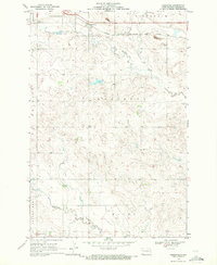 1969 Gascoyne1971 Print · USGSBowman County prairie life in the late sixties centers on the railroad corridor and the small hub of Gascoyne. Genealogists and historians can trace the local infrastructure including the Chicago Milwaukee St Paul and Pacific rail line and the nearby Strip Mine.2 unique versions available
 - 1969 Map of Scranton NE, 1971 Print
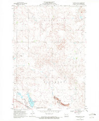 1969 Scranton NE1971 Print · USGSBowman County, North Dakota, is documented here in the late sixties, showing the vital intersection of rail and water. You can trace the Chicago Milwaukee St Paul and Pacific railroad as it skirts Gascoyne Lake and the Gascoyne Corporate Bdy.
End of results
Showing maps 1-2 of 2
Top cities near Gascoyne
Frequently asked questions
- What are the different types of historical maps available for Gascoyne?
- What is the oldest map of Gascoyne?
- Where can I purchase historical maps of Gascoyne for my home or office?
- Where can I download high-res historical maps of Gascoyne?
- Are there historical topographic maps available for Gascoyne?
- Is there historical aerial imagery available for Gascoyne?
- Where are historical maps of Gascoyne sourced from?