1940s Maps of Lignite, North Dakota
Explore 2 historic maps of Lignite from the 1940s. These maps offer a rare glimpse into what life looked like during the 1940s — showing old roads, neighborhoods, homes, and landmarks that have changed or disappeared over time.
Whether you're researching your family's past, planning a metal detecting trip, or studying how Lignite's landscape evolved across the 1940s, these high-resolution maps are a powerful tool for exploring the history of this region.
- Focus on a specific era: All maps on this page are from the 1940s, giving you a focused view of this time period.
- See what’s changed: Compare century-old streets, trails, and buildings to today's modern landscape using overlays and satellite layers.
- Research with precision: Use these maps for genealogy, historical research, land use analysis, or educational projects.
- View, download, or print: Maps are fully viewable online in high resolution, and can be downloaded or printed for your own records.
Start exploring Lignite's history through authentic maps from the 1940s. This is your window into the past.
Lignite, ND maps
(2)- 1949 Map of Rennie Lake
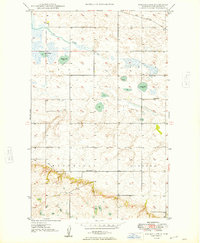 1949 Rennie Lake1949 Print · USGSNorthwestern North Dakota's prairie landscape is captured here in the late Forties, showing the intersection of rail transit and rural education. You can trace the Great Northern rail line past local landmarks like Scandia Sch and Rennie Lake.
 - 1949 Map of Portal
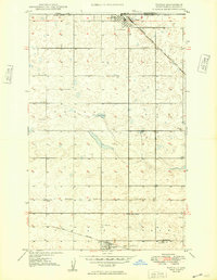 1949 Portal1949 Print · USGSThe border country of Burke County comes into focus just after the war as Portal and Lignite thrive along the railroad lines. Genealogists can trace family footprints through numerous local landmarks, including the St. Marys Cem, Scontia Sch, and the Norwegian Cem.
End of results
Showing maps 1-2 of 2
Top cities near Lignite
Frequently asked questions
- What are the different types of historical maps available for Lignite?
- What is the oldest map of Lignite?
- Where can I purchase historical maps of Lignite for my home or office?
- Where can I download high-res historical maps of Lignite?
- Are there historical topographic maps available for Lignite?
- Is there historical aerial imagery available for Lignite?
- Where are historical maps of Lignite sourced from?