1970s Maps of Niagara, North Dakota
Explore 2 historic maps of Niagara from the 1970s. These maps offer a rare glimpse into what life looked like during the 1970s — showing old roads, neighborhoods, homes, and landmarks that have changed or disappeared over time.
Whether you're researching your family's past, planning a metal detecting trip, or studying how Niagara's landscape evolved across the 1970s, these high-resolution maps are a powerful tool for exploring the history of this region.
- Focus on a specific era: All maps on this page are from the 1970s, giving you a focused view of this time period.
- See what’s changed: Compare century-old streets, trails, and buildings to today's modern landscape using overlays and satellite layers.
- Research with precision: Use these maps for genealogy, historical research, land use analysis, or educational projects.
- View, download, or print: Maps are fully viewable online in high resolution, and can be downloaded or printed for your own records.
Start exploring Niagara's history through authentic maps from the 1970s. This is your window into the past.
Niagara, ND maps
(2)- 1971 Map of Fordville SW, 1974 Print
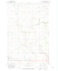 1971 Fordville SW1974 Print · USGSNelson and Grand Forks counties appear here in the early 1970s, showing a prairie landscape defined by the Burlington Northern rail line. Researchers can trace the layout of Petersburg, find the St Andrews Cem, and follow the winding path of Skunk Coulee.
 - 1971 Map of Lake Pickard, 1974 Print
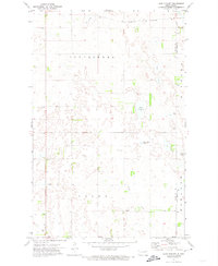 1971 Lake Pickard1974 Print · USGSThe borderlands of Nelson and Grand Forks counties come into focus during the early seventies, showing a landscape defined by prairie water and rural townships. Genealogists and local historians can locate Lom Ch, the local Townhall, and the winding Goose River.
End of results
Showing maps 1-2 of 2
Top cities near Niagara
- Fordville historical maps
- Petersburg historical maps
- Inkster historical maps
- Dahlen historical maps
- Logan Center historical maps
Frequently asked questions
- What are the different types of historical maps available for Niagara?
- What is the oldest map of Niagara?
- Where can I purchase historical maps of Niagara for my home or office?
- Where can I download high-res historical maps of Niagara?
- Are there historical topographic maps available for Niagara?
- Is there historical aerial imagery available for Niagara?
- Where are historical maps of Niagara sourced from?