1900s (20th Century) Maps of Mott, North Dakota
Explore 5 historic maps of Mott from the 1900s (20th Century). These maps offer a rare glimpse into what life looked like during the 1900s — showing old roads, neighborhoods, homes, and landmarks that have changed or disappeared over time.
Whether you're researching your family's past, planning a metal detecting trip, or studying how Mott's landscape evolved across the 1900s, these high-resolution maps are a powerful tool for exploring the history of this region.
- Focus on a specific era: All maps on this page are from the 1900s, giving you a focused view of this time period.
- See what’s changed: Compare century-old streets, trails, and buildings to today's modern landscape using overlays and satellite layers.
- Research with precision: Use these maps for genealogy, historical research, land use analysis, or educational projects.
- View, download, or print: Maps are fully viewable online in high resolution, and can be downloaded or printed for your own records.
Start exploring Mott's history through authentic maps from the 1900s. This is your window into the past.
Mott, ND maps
(5)- 1953 Map of Dickinson, 1968 Print
 1953 Dickinson1968 Print · USGSWestern North Dakota in the fifties remains a landscape of rail-linked prairie towns and rugged badlands. Trace the local impact of the Northern Pacific railroad through Dickinson or locate early rural landmarks like Rainy Butte Church and Boys Ranch.2 unique versions available
 - 1957 Map of Dickinson
 1957 Dickinson1957 Print · USGSSouthwestern North Dakota in the mid-fifties is a landscape of coal mining and tight-knit rural school districts. Genealogists can trace family footprints through numerous country schools like Fisher School and parish churches like St Stephens.
 - 1966 Map of Mott South, 1967 Print
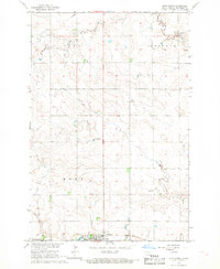
 1966 Mott South1967 Print · USGSHettinger County in the mid-sixties shows the town of Mott as a critical rail and river hub for the surrounding ranchlands. Genealogists and historians can trace the local infrastructure of the era, from the Fairground to the tracks of the Northern Pacific.
 - 1966 Map of Mott North, 1967 Print
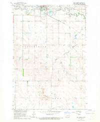
 1966 Mott North1967 Print · USGSHettinger County, North Dakota, is documented here in the mid-1960s as the town of Mott thrived along the Missouri River Basin. Genealogists and local historians can trace the Milwaukee Road railroad, locate the Sunny Slope Cem, and follow Spring Creek through the prairie.
 - 1980 Map of Mott, 1981 Print
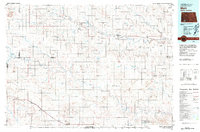 1980 Mott1981 Print · USGSThe North Dakota plains around the turn of the 1980s reveal a landscape of river-valley farming and critical rail connections. Researchers can trace the path of the Milwaukee Road through Bucyrus or locate landmarks like East Rainy Butte and Tepee Buttes.
End of results
Showing maps 1-5 of 5
Frequently asked questions
- What are the different types of historical maps available for Mott?
- What is the oldest map of Mott?
- Where can I purchase historical maps of Mott for my home or office?
- Where can I download high-res historical maps of Mott?
- Are there historical topographic maps available for Mott?
- Is there historical aerial imagery available for Mott?
- Where are historical maps of Mott sourced from?