1900s (20th Century) Maps of Dawson, North Dakota
Explore 8 historic maps of Dawson from the 1900s (20th Century). These maps offer a rare glimpse into what life looked like during the 1900s — showing old roads, neighborhoods, homes, and landmarks that have changed or disappeared over time.
Whether you're researching your family's past, planning a metal detecting trip, or studying how Dawson's landscape evolved across the 1900s, these high-resolution maps are a powerful tool for exploring the history of this region.
- Focus on a specific era: All maps on this page are from the 1900s, giving you a focused view of this time period.
- See what’s changed: Compare century-old streets, trails, and buildings to today's modern landscape using overlays and satellite layers.
- Research with precision: Use these maps for genealogy, historical research, land use analysis, or educational projects.
- View, download, or print: Maps are fully viewable online in high resolution, and can be downloaded or printed for your own records.
Start exploring Dawson's history through authentic maps from the 1900s. This is your window into the past.
Dawson, ND maps
(8)- 1952 Map of Tappen South, 1954 Print
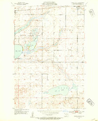 1952 Tappen South1954 Print · USGSIn the early fifties, this Kidder County landscape was defined by the Northern Pacific rail corridor and a vast network of wetlands. Researchers can trace the layout of early rural life through landmarks like Camp Grassick, Sibley Cem, and the old School No 28.
 - 1952 Map of Dawson, 1954 Print
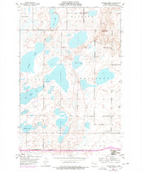
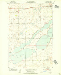 1952 Dawson1954 Print · USGSKidder County in the early 1950s was a landscape of expansive prairie lakes and railroad-dependent towns. Genealogists and local historians can trace the rural schoolhouse at Liberty Sch and the rail-side growth of Dawson near Alkaline Lake.2 unique versions available
 - 1952 Map of Tappen North, 1954 Print
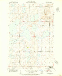 1952 Tappen North1954 Print · USGSKidder County's prairie pothole region is detailed here in the early fifties, showing a rural landscape organized by township lines and small rail-side settlements. Researchers can locate family landmarks like the Norwegian Ch, Fisher Cem, and McPhail Butte Historic Monument.
 - 1952 Map of Steele NE, 1954 Print
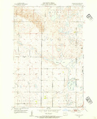 1952 Steele NE1954 Print · USGSKidder County's prairie wetland system is captured here in the early fifties as the community of Dawson began its post-war decade. Genealogists and local historians can locate early landmarks like Allen Cem and rural educational sites like School No 1.2 unique versions available
 - 1953 Map of Jamestown
 1953 Jamestown1953 Print · USGSSoutheastern North Dakota was a thriving rail and agricultural corridor in the early fifties, anchored by the James River. Researchers can trace the footprints of institutional landmarks like the North Dakota State Hospital and historic sites such as Whitestone Hill Battlefield Park.3 unique versions available
 - 1956 Map of Jamestown
 1956 Jamestown1956 Print · USGSThe James River valley and the vast alkali lake country of south-central North Dakota are captured here in the mid-fifties. Genealogists can trace family farms across several counties, locating small rail stops like Medberry and monuments like Whitestone Hill Battlefield Park.
 - 1975 Map of Tappen North, 1978 Print
 1975 Tappen North1978 Print · USGSKidder County's prairie pothole region is captured here in the mid-seventies, showing a landscape of expansive lakes and rural townships. Genealogists and local historians can locate Fisher Cem, Norwegian Ch, and early school sites like School No 2.
 - 1985 Map of Steele, 1994 Print
 1985 Steele1994 Print · USGSCentral North Dakota’s prairie pothole region is showcased here in the mid-1980s, revealing a landscape of vital wetlands and rail-dependent towns. Researchers can trace family ties and land use near Steele, Napoleon, and the many waterfowl production areas like Slade National Wildlife Refuge.
End of results
Showing maps 1-8 of 8
Top cities near Dawson
Frequently asked questions
- What are the different types of historical maps available for Dawson?
- What is the oldest map of Dawson?
- Where can I purchase historical maps of Dawson for my home or office?
- Where can I download high-res historical maps of Dawson?
- Are there historical topographic maps available for Dawson?
- Is there historical aerial imagery available for Dawson?
- Where are historical maps of Dawson sourced from?