1960s Maps of Mandaree, North Dakota
Explore 7 historic maps of Mandaree from the 1960s. These maps offer a rare glimpse into what life looked like during the 1960s — showing old roads, neighborhoods, homes, and landmarks that have changed or disappeared over time.
Whether you're researching your family's past, planning a metal detecting trip, or studying how Mandaree's landscape evolved across the 1960s, these high-resolution maps are a powerful tool for exploring the history of this region.
- Focus on a specific era: All maps on this page are from the 1960s, giving you a focused view of this time period.
- See what’s changed: Compare century-old streets, trails, and buildings to today's modern landscape using overlays and satellite layers.
- Research with precision: Use these maps for genealogy, historical research, land use analysis, or educational projects.
- View, download, or print: Maps are fully viewable online in high resolution, and can be downloaded or printed for your own records.
Start exploring Mandaree's history through authentic maps from the 1960s. This is your window into the past.
Mandaree, ND maps
(7)- 1965 Map of Blue Buttes SE, 1967 Print
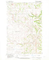 1965 Blue Buttes SE1967 Print · USGSMcKenzie County was a landscape of remote ranching and reservation lands in the mid-1960s. Genealogists and researchers can trace the Fort Berthold Indian Reservation Boundary and find local landmarks like the Scoria Pit and Aura Butte.
 - 1967 Map of Watford City
 1967 Watford City1967 Print · USGSWestern North Dakota is captured during a period of landscape transformation as the Missouri River valley was reshaped by the new Garrison Reservoir. Genealogists and local historians can trace the foundations of Watford City, find the Elkhorn Ranch Site, or locate rural landmarks like Ziner Butte and Grassy Butte.
 - 1967 Map of Sanish SE, 1969 Print
 1967 Sanish SE1969 Print · USGSThe Missouri River breaks in Mountrail County are shown during a transformative era in the late sixties as the reservoir fills the valley. Researchers can trace the Fort Berthold Indian Reservation Boundary and locate Shell Creek Ch and the Little Shell Creek Public Use Area.
 - 1967 Map of Twin Buttes, 1969 Print
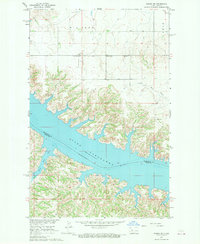
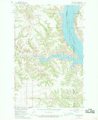
 1967 Twin Buttes1969 Print · USGSThe rising waters of Lake Sakakawea define this part of Mercer and Dunn County during the late 1960s. Researchers can locate numerous local landmarks including St Joseph Ch, Twin Buttes, and several rural cemeteries like Chase Cem.
 - 1967 Map of New Town SW, 1970 Print
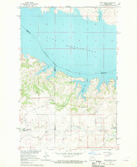
 1967 New Town SW1970 Print · USGSMountrail County's shoreline was dramatically reshaped by the mid-1960s as the Missouri River valley transitioned into a vast reservoir. Researchers can trace the Fort Berthold Indian Reservation Boundary and locate local landmarks like Little Shell Ch and the Van Hook State Game Management Area.
 - 1967 Map of Sanish SW, 1970 Print
 1967 Sanish SW1970 Print · USGSMcKenzie County's badlands terrain meets the rising waters of the Missouri River in the late sixties. Trace the inundated shoreline of Lake Sakakawea and find landmarks like Blue Butte or the Bear Den Creek Public Use Area.
 - 1967 Map of New Town SE, 1970 Print
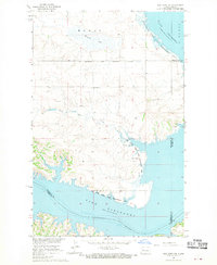
 1967 New Town SE1970 Print · USGSLake Sakakawea and the Missouri River Basin were undergoing significant transformation in the late sixties as reservoir waters reshaped the landscape. Researchers can trace submerged river channels and shoreline features like Independence Point and Lucky Mound Creek Bay.
End of results
Showing maps 1-7 of 7
Top cities near Mandaree
Top neighborhoods of Mandaree
Frequently asked questions
- What are the different types of historical maps available for Mandaree?
- What is the oldest map of Mandaree?
- Where can I purchase historical maps of Mandaree for my home or office?
- Where can I download high-res historical maps of Mandaree?
- Are there historical topographic maps available for Mandaree?
- Is there historical aerial imagery available for Mandaree?
- Where are historical maps of Mandaree sourced from?