1960s Maps of Morton County, North Dakota
Explore 14 historic maps of Morton County from the 1960s. These maps offer a rare glimpse into what life looked like during the 1960s — showing old roads, neighborhoods, homes, and landmarks that have changed or disappeared over time.
Whether you're researching your family's past, planning a metal detecting trip, or studying how Morton County's landscape evolved across the 1960s, these high-resolution maps are a powerful tool for exploring the history of this region.
- Focus on a specific era: All maps on this page are from the 1960s, giving you a focused view of this time period.
- See what’s changed: Compare century-old streets, trails, and buildings to today's modern landscape using overlays and satellite layers.
- Research with precision: Use these maps for genealogy, historical research, land use analysis, or educational projects.
- View, download, or print: Maps are fully viewable online in high resolution, and can be downloaded or printed for your own records.
Start exploring Morton County's history through authentic maps from the 1960s. This is your window into the past.
Morton County, ND maps
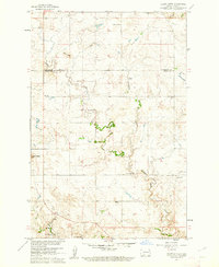
(14)- 1960 Map of North Almont, 1961 Print
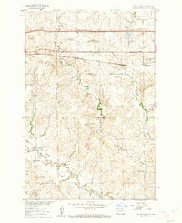 1960 North Almont1961 Print · USGSMorton County in the early sixties shows a landscape of rail-driven prairie life and winding coulees. Genealogists and historians can trace local landmarks like Benson Sch, Peace Ch, and the defunct Old Railroad Grade.
 - 1960 Map of Dengate, 1961 Print
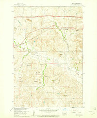 1960 Dengate1961 Print · USGSMorton County in the early sixties is a landscape of rural schools and rail-side settlements along the Curlew Valley. Genealogists and historians can trace the foundations of Dengate, locate School No 4, or explore the coal-rich hills near a Strip Mine.2 unique versions available
 - 1960 Map of New Salem, 1961 Print
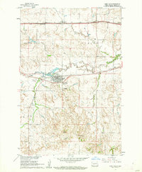
 1960 New Salem1961 Print · USGSNew Salem and the surrounding Morton County prairies are captured here in the early sixties as modern highways began to bypass the old rail towns. Genealogists and researchers can trace the Northern Pacific line, the Old Railroad Grade, and local landmarks like Graceland Cem and Klondike Butte.2 unique versions available
 - 1960 Map of Glen Ullin, 1962 Print
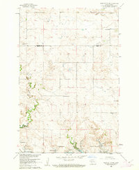
 1960 Glen Ullin1962 Print · USGSThe Missouri River Basin development era finds Glen Ullin at a crossroads of classic rail and modern interstate expansion. Trace the community's mid-century landscape through the Northern Pacific line, Tavis Sch No 8, and landmarks like Horseshoe Butte.2 unique versions available
 - 1960 Map of Heart Butte NW, 1962 Print
 1960 Heart Butte NW1962 Print · USGSThe prairie of Morton and Grant counties is shown in the early 1960s as the Missouri River Basin development reshaped the landscape. Genealogy researchers can trace rural school districts like Heart Butte Sch No 5 and local burials at Koehler Cem.
 - 1960 Map of Clark Butte NE, 1962 Print
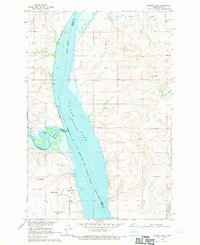
 1960 Clark Butte NE1962 Print · USGSThe North Dakota prairie near the intersection of Grant, Morton, and Stark counties is captured here in the early sixties. Researchers can find rural landmarks such as SS Peter and Paul Ch, Heart Butte School No 2, and the newly formed Lake Tschida.
 - 1960 Map of Heart Butte, 1962 Print
 1960 Heart Butte1962 Print · USGSThe Grant County plains in the early sixties show a transition from traditional prairie life to the era of large-scale water projects. Trace the location of many rural schoolhouses like Hertz Sch No 2 and the historic Old St Joseph Cem.
 - 1962 Map of Sugarloaf Butte, 1963 Print
 1962 Sugarloaf Butte1963 Print · USGSThe Missouri River bottoms south of Bismarck were in transition during the early sixties as reservoir waters began to rise. Genealogists and historians can trace the Old Fort Rice Military Road, locate Manning School No 1, and find the Stewardsdale Cem.
 - 1962 Map of Schmidt, 1963 Print
 1962 Schmidt1963 Print · USGSThe Missouri River valley south of Bismarck underwent a major transition in the early sixties as the rising waters of the Oahe Reservoir began to reshape the landscape. Local historians can trace the boundaries of the Old Fort Lincoln Military Reservation and locate rural landmarks like Bonanza Sch No 4 and Schmidt.2 unique versions available
 - 1962 Map of Bismarck, 1964 Print
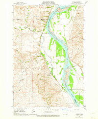
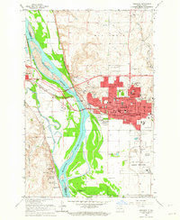 1962 Bismarck1964 Print · USGSBismarck and Mandan face each other across the Missouri River in the early 1960s during a period of significant capital expansion. Trace the historical roots of the region at the Fort Lincoln Historic Site Ruins, the Capitol grounds, and the Northern Pacific rail yards.3 unique versions available
 - 1962 Map of Harmon, 1964 Print
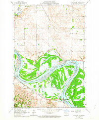
 1962 Harmon1964 Print · USGSThe Missouri River valley north of Bismarck comes alive in the early sixties, showing a landscape of riverside settlements and active rail lines. Genealogists and historians can trace the Northern Pacific tracks through Harmon or locate Square Butte School No 1 and the Double Ditch Indian Village.2 unique versions available
 - 1962 Map of Mandan, 1964 Print
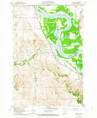
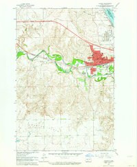 1962 Mandan1964 Print · USGSMandan was a bustling rail and energy hub in the early sixties where the Heart and Missouri rivers meet. Genealogists and historians can trace the town's growth through its many neighborhood institutions, including St Joseph Sch, the State Training School, and Custer Sch No 1.2 unique versions available
 - 1968 Map of Cannon Ball, 1971 Print
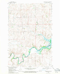
 1968 Cannon Ball1971 Print · USGSThe Missouri River valley near the Standing Rock Indian Reservation is shown here in the late sixties as Lake Oahe reshaped the landscape. Trace the local geography of Cannon Ball, from the Cannon Ball Memorial Congregational Cem to the Old Railroad Grade.2 unique versions available
 - 1968 Map of Cannon Ball NW, 1971 Print
 1968 Cannon Ball NW1971 Print · USGSThe Missouri River Basin landscape appears here in the late sixties, showcasing the intersection of tribal and military lands. Researchers can trace the Old Railroad Grade along the Cannonball River and locate the historic Fort Rice Military Reservation boundary.
End of results
Showing maps 1-14 of 14
Top cities of Morton County
- Mandan historical maps
- New Salem historical maps
- Glen Ullin historical maps
- Hebron historical maps
- Flasher historical maps
- Almont historical maps
Frequently asked questions
- What are the different types of historical maps available for Morton County?
- What is the oldest map of Morton County?
- Where can I purchase historical maps of Morton County for my home or office?
- Where can I download high-res historical maps of Morton County?
- Are there historical topographic maps available for Morton County?
- Is there historical aerial imagery available for Morton County?
- Where are historical maps of Morton County sourced from?