1960s Maps of Pembina County, North Dakota
Explore 15 historic maps of Pembina County from the 1960s. These maps offer a rare glimpse into what life looked like during the 1960s — showing old roads, neighborhoods, homes, and landmarks that have changed or disappeared over time.
Whether you're researching your family's past, planning a metal detecting trip, or studying how Pembina County's landscape evolved across the 1960s, these high-resolution maps are a powerful tool for exploring the history of this region.
- Focus on a specific era: All maps on this page are from the 1960s, giving you a focused view of this time period.
- See what’s changed: Compare century-old streets, trails, and buildings to today's modern landscape using overlays and satellite layers.
- Research with precision: Use these maps for genealogy, historical research, land use analysis, or educational projects.
- View, download, or print: Maps are fully viewable online in high resolution, and can be downloaded or printed for your own records.
Start exploring Pembina County's history through authentic maps from the 1960s. This is your window into the past.
Pembina County, ND maps
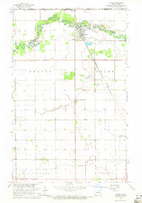
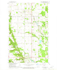
(15)- 1963 Map of Crystal SE, 1964 Print
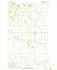
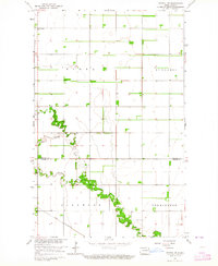 1963 Crystal SE1964 Print · USGSPembina County farming townships are captured here in the early sixties as the rural grid of the Red River Valley remained firmly established. Genealogists and local historians can locate St Johns Ch or trace the path of the Great Northern railroad near the North Branch Park River.
 - 1963 Map of Crystal, 1964 Print
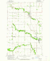 1963 Crystal1964 Print · USGSNortheastern North Dakota's agricultural heartland is captured here in the early sixties as a network of rail-side towns and rural townships. Genealogists and local historians can trace family locations near Crystal, Hoople, and the West Point Cem.2 unique versions available
 - 1963 Map of Gardar, 1964 Print
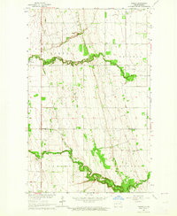 1963 Gardar1964 Print · USGSNortheastern North Dakota's prairie landscape is captured here in the early sixties, showing the rural townships of Gardar and Crystal. Genealogists can locate family landmarks like Stokesville Cem and the Hvidsten Ch Cem along the branches of the Park River.
 - 1964 Map of Mountain, 1965 Print
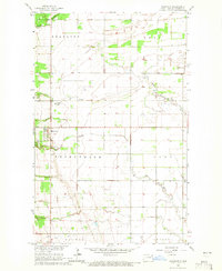 1964 Mountain1965 Print · USGSPembina County's Icelandic settlement patterns and agricultural landscape are clearly visible in the mid-1960s. Genealogists can trace the rural communities through landmarks like Eyford Ch, Mountain Cem, and the meandering Tongue River.
 - 1964 Map of Hensel, 1965 Print
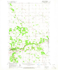
 1964 Hensel1965 Print · USGSPembina County's agricultural heartland is captured in the mid-1960s, showing a landscape defined by the township grid and small-town commerce. Genealogists and historians can locate Vidalin Ch, trace the Great Northern rail line, and find the dual-named Hensel (Canton).
 - 1964 Map of Hallson, 1965 Print
 1964 Hallson1965 Print · USGSNortheastern North Dakota in the mid-sixties shows a rural landscape defined by the Tongue River and the small settlements of Svold and Hallson. Researchers can trace local lineage through numerous sites like Old Peters Cem, Andvari Cem, and the Pleasance Sch.
 - 1964 Map of Leroy, 1965 Print
 1964 Leroy1965 Print · USGSThe northern edge of Pembina County meets the Canadian border in the mid-1960s, where the winding river valley cuts through a rigid prairie grid. Genealogists and historians can locate the community of Leroy, the St Joseph Cem, and the Great Northern rail line near Leyden.2 unique versions available
 - 1964 Map of Walhalla, 1965 Print
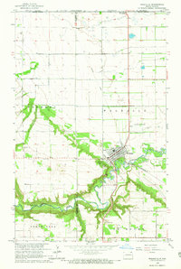 1964 Walhalla1965 Print · USGSWalhalla and the Pembina River valley are captured in the mid-sixties, showing the town's transition from the wooded escarpment to the open plains. Researchers can locate the Walhalla Cem, trace the Great Northern railroad, or identify the Port of Entry US Customs at the international border.3 unique versions available
 - 1964 Map of Neche, 1965 Print
 1964 Neche1965 Print · USGSThe border country of Pembina County in the mid-1960s is defined by the winding Pembina River and the critical rail link at Neche. Genealogists and local historians can locate the Port of Entry US Customs, Union Cem, and the Great Northern tracks.
 - 1964 Map of Backoo, 1965 Print
 1964 Backoo1965 Print · USGSPembina County's prairie landscape was a hub of transit and recreation in the mid-1960s. Genealogists and historians can trace the Great Northern rail corridor and find local landmarks like the Townhall at Backoo and Renwick Dam.
 - 1964 Map of Concrete, 1965 Print
 1964 Concrete1965 Print · USGSThe border of Cavalier and Pembina counties comes into focus in the 1960s, showing the rural townships of the Red River Valley hinterlands. Researchers can locate the settlement of Concrete, family-relevant sites like St Ellens Cem, and the winding path of the Tongue River.
 - 1964 Map of Cavalier, 1965 Print
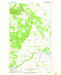
 1964 Cavalier1965 Print · USGSThe Red River Valley landscape around the mid-1960s shows a structured agricultural community centered on the city of Cavalier. Researchers can trace the winding course of the Tongue River and locate historic burial sites at Zion Cem and the local Cem.
 - 1964 Map of Hanks Corner, 1966 Print
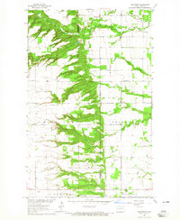
 1964 Hanks Corner1966 Print · USGSNortheast North Dakota during the mid-sixties shows a landscape of carefully managed prairie water and rural townships. Genealogists and local historians can trace the family lands surrounding Hanks Corner, Beaulieu Cemetery, and Oak Lawn Cemetery.
 - 1964 Map of Cavalier NW, 1966 Print
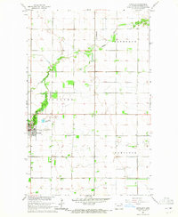
 1964 Cavalier NW1966 Print · USGSPembina County at the height of the mid-century agricultural era shows a landscape defined by the winding Pembina River and rural homesteads. Genealogists can locate family landmarks like Hyde Park Cem, Tyner Cem, and the Park Center Ch.
 - 1967 Map of Thief River Falls
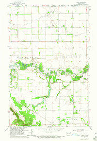
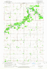
 1967 Thief River Falls1967 Print · USGSThe Red River Valley and the international border come alive in the 1960s, showing a landscape shaped by major rail lines and river commerce. Genealogists and historians can trace the paths of the Great Northern and Soo Line through towns like Thief River Falls, Grafton, and Hallock.
End of results
Showing maps 1-15 of 15
Top cities of Pembina County
- Cavalier historical maps
- Walhalla historical maps
- Drayton historical maps
- Pembina historical maps
- Neche historical maps
- Akra Township historical maps
See more
Frequently asked questions
- What are the different types of historical maps available for Pembina County?
- What is the oldest map of Pembina County?
- Where can I purchase historical maps of Pembina County for my home or office?
- Where can I download high-res historical maps of Pembina County?
- Are there historical topographic maps available for Pembina County?
- Is there historical aerial imagery available for Pembina County?
- Where are historical maps of Pembina County sourced from?