Old Maps of Pembina County, North Dakota
Explore 224 old maps of Pembina County, spanning from 1918 to today. These high-resolution historic maps reveal how streets, neighborhoods, landmarks, and natural features evolved over time — perfect for genealogy, metal detecting, research, and local history exploration.
What you can do with these maps:
- See how Pembina County changed over time: Compare historical maps to modern-day views to trace roads, homesites, rail lines & more.
- View detailed metadata: Each map includes creators, publishers, year, scale, and archive source.
- Overlay maps with satellite & LiDAR: Visualize the past alongside modern tools to explore terrain & human change.
- Trusted historical sources: Maps sourced from the USGS, Library of Congress, and other archives.
- Access maps your way: View online, download high-res files, or order prints for personal or research use.
Start exploring old maps of Pembina County to uncover forgotten places, hidden landmarks, and the deep history beneath your feet.
Pembina County, ND maps
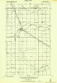
(224)- 1918 Map of Walhalla
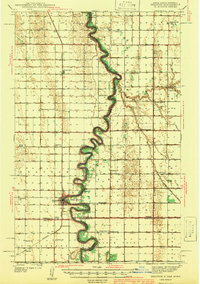
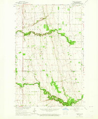
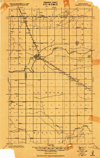 1918 Walhalla1918 Print · USGSThe North Dakota borderlands come into focus at the end of the Great War, showing a landscape of pioneer townships and river valleys. Genealogists can trace family footprints near Walhalla and Beaulieu, or locate long-standing rural Schools and the Great Northern R.R. line.
 - 1939 Map of Drayton, 1954 Print
 1939 Drayton1954 Print · USGSThe Red River valley at the onset of the Second World War shows a landscape defined by tight river bends and a thriving railroad economy. Genealogists and local historians can trace family locations near dozens of rural schools and churches like Daymon Sch, Tabitha Ch, and the settlement of Bowesmont.2 unique versions available
 - 1939 Map of Glasston, 1958 Print
 1939 Glasston1958 Print · USGSNorth Dakota's fertile Red River Valley is captured here in the late 1930s, showing a landscape defined by rail and agriculture. Trace the Great Northern line to find Sugar Siding or locate early rural schools like Union Sch and School No 52.
 - 1939 Map of Pembina, 1958 Print
 1939 Pembina1958 Print · USGSThe international border at the Red River Valley was a busy corridor of rail and river transit in the late 1930s. Genealogists can locate numerous rural schoolhouses like Fleece Sch and Joe River Sch, or trace the tracks of the Great Northern through St Vincent.3 unique versions available
 - 1939 Map of Cavalier, 1960 Print
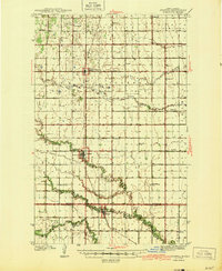
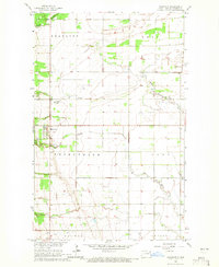
 1939 Cavalier1960 Print · USGSNortheastern North Dakota's border country is captured here in the late 1930s, showing a landscape defined by the Great Northern rail line and rural townships. Researchers can trace local school districts from Leyden Sch to Fairport Sch and locate vanished landmarks like Hughes Ch and Hyde Park Cem.
 - 1941 Map of Drayton
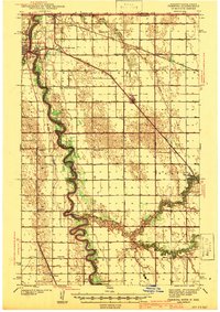
 1941 Drayton1941 Print · USGSThe Red River of the North snakes across the border of North Dakota and Minnesota during the late 1930s. Genealogists and historians can trace rail-side towns like Bowesmont and Drayton, or locate rural landmarks such as Skjeberg Ch and the Airway Beacon.2 unique versions available
 - 1941 Map of Glasston
 1941 Glasston1941 Print · USGSThe Red River Valley's agricultural heartland is documented here just before the mid-century, showing a landscape defined by rail-side elevators and rural townships. Researchers can trace family roots through numerous country schools like Quam Sch and landmarks such as the Norwegian Cem near Sugar Siding.
 - 1941 Map of Cavalier
 1941 Cavalier1941 Print · USGSPembina County sits on the international border during the late 1930s, showing a landscape defined by the Great Northern rail lines and meandering rivers. Researchers can trace the exact locations of numerous vanished rural schoolhouses like Crosby Sch and family landmarks such as Horrigan Ridge.
 - 1941 Map of Bathgate
 1941 Bathgate1941 Print · USGSNortheastern North Dakota's borderlands are captured here in the late 1930s, showing a landscape defined by meandering rivers and a dense network of rural schoolhouses. Genealogists can locate family-named landmarks like Geroux Bridge Sch, Murphy Sch, and the Bathgate Cem.
 - 1941 Map of Pembina
 1941 Pembina1941 Print · USGSThe Red River valley at the Canadian border comes alive in this pre-war survey of the North Dakota-Minnesota line. Genealogists can trace family roots through numerous rural landmarks like the Icelandic Cem, North Star Ch, and the Fleece Sch.2 unique versions available
 - 1943 Map of Walhalla
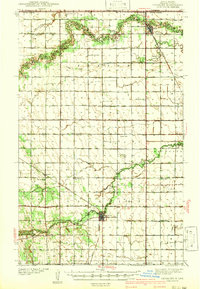
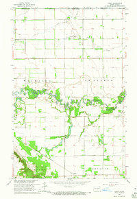
 1943 Walhalla1943 Print · USGSSettlement along the international border is captured here during the 1940s, centered on the railroad corridor. Genealogists can locate family sites near Walhalla, the rural schoolhouses of Beaulieu, or the Bay Center Church.
 - 1944 Map of Crystal
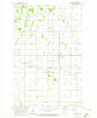
 1944 Crystal1944 Print · USGSPembina and Walsh Counties during the early 1940s show a landscape of rail-reliant prairie towns and numerous one-room schoolhouses. Genealogists can locate family-named landmarks like Scheving Sch and Fisher Sch or the rural St Johns Ch.
 - 1952 Map of Thief River Falls, 1967 Print
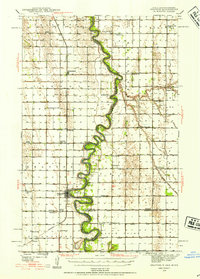
 1952 Thief River Falls1967 Print · USGSThe Red River Valley's agricultural and conservation landscape is captured in the mid-1950s, detailing a web of rail lines and international border crossings. Researchers can trace family roots in towns like Thief River Falls, locate the State School for Blind, and survey landmarks like the Agassiz National Wildlife Refuge.2 unique versions available
 - 1956 Map of Thief River Falls
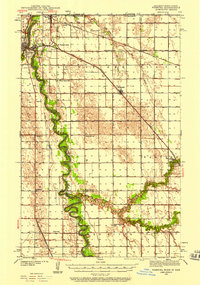
 1956 Thief River Falls1956 Print · USGSThe Red River Valley in the mid-1950s is captured here as a sprawling network of rail corridors and wildlife refuges along the Canadian border. Trace the vanished transport routes of the Dismantled railroad and Abandoned railroad or locate local landmarks like the Herrick Elevator and State School for Blind.
 - 1957 Map of Thief River Falls
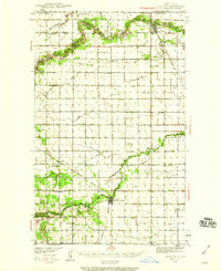
 1957 Thief River Falls1957 Print · USGSThe Red River Valley in the mid-fifties is captured here as a thriving network of rail towns and conservation lands. Genealogists and historians can trace family roots through settlements like Grafton, Pembina, and Hallock, or locate landmarks such as the State School for Blind and the Great Northern RR corridor.
 - 1963 Map of Crystal SE, 1964 Print
 1963 Crystal SE1964 Print · USGSPembina County farming townships are captured here in the early sixties as the rural grid of the Red River Valley remained firmly established. Genealogists and local historians can locate St Johns Ch or trace the path of the Great Northern railroad near the North Branch Park River.
 - 1963 Map of Crystal, 1964 Print
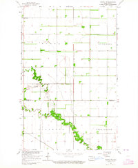
 1963 Crystal1964 Print · USGSNortheastern North Dakota's agricultural heartland is captured here in the early sixties as a network of rail-side towns and rural townships. Genealogists and local historians can trace family locations near Crystal, Hoople, and the West Point Cem.2 unique versions available
 - 1963 Map of Gardar, 1964 Print
 1963 Gardar1964 Print · USGSNortheastern North Dakota's prairie landscape is captured here in the early sixties, showing the rural townships of Gardar and Crystal. Genealogists can locate family landmarks like Stokesville Cem and the Hvidsten Ch Cem along the branches of the Park River.
 - 1964 Map of Mountain, 1965 Print
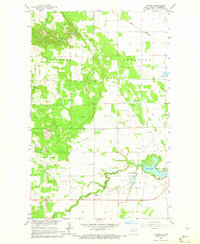
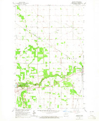
 1964 Mountain1965 Print · USGSPembina County's Icelandic settlement patterns and agricultural landscape are clearly visible in the mid-1960s. Genealogists can trace the rural communities through landmarks like Eyford Ch, Mountain Cem, and the meandering Tongue River.
 - 1964 Map of Hensel, 1965 Print
 1964 Hensel1965 Print · USGSPembina County's agricultural heartland is captured in the mid-1960s, showing a landscape defined by the township grid and small-town commerce. Genealogists and historians can locate Vidalin Ch, trace the Great Northern rail line, and find the dual-named Hensel (Canton).
 - 1964 Map of Hallson, 1965 Print
 1964 Hallson1965 Print · USGSNortheastern North Dakota in the mid-sixties shows a rural landscape defined by the Tongue River and the small settlements of Svold and Hallson. Researchers can trace local lineage through numerous sites like Old Peters Cem, Andvari Cem, and the Pleasance Sch.
 - 1964 Map of Leroy, 1965 Print
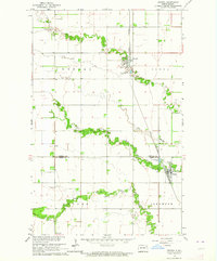
 1964 Leroy1965 Print · USGSThe northern edge of Pembina County meets the Canadian border in the mid-1960s, where the winding river valley cuts through a rigid prairie grid. Genealogists and historians can locate the community of Leroy, the St Joseph Cem, and the Great Northern rail line near Leyden.2 unique versions available
 - 1964 Map of Walhalla, 1965 Print
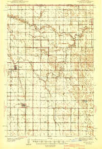
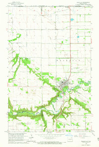 1964 Walhalla1965 Print · USGSWalhalla and the Pembina River valley are captured in the mid-sixties, showing the town's transition from the wooded escarpment to the open plains. Researchers can locate the Walhalla Cem, trace the Great Northern railroad, or identify the Port of Entry US Customs at the international border.3 unique versions available
 - 1964 Map of Neche, 1965 Print
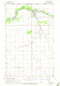 1964 Neche1965 Print · USGSThe border country of Pembina County in the mid-1960s is defined by the winding Pembina River and the critical rail link at Neche. Genealogists and local historians can locate the Port of Entry US Customs, Union Cem, and the Great Northern tracks.
 - 1964 Map of Backoo, 1965 Print
 1964 Backoo1965 Print · USGSPembina County's prairie landscape was a hub of transit and recreation in the mid-1960s. Genealogists and historians can trace the Great Northern rail corridor and find local landmarks like the Townhall at Backoo and Renwick Dam.
Showing maps 1-25 of 224
Top cities of Pembina County
- Cavalier historical maps
- Walhalla historical maps
- Drayton historical maps
- Pembina historical maps
- Neche historical maps
- Akra Township historical maps
See more
Frequently asked questions
- What are the different types of historical maps available for Pembina County?
- What is the oldest map of Pembina County?
- Where can I purchase historical maps of Pembina County for my home or office?
- Where can I download high-res historical maps of Pembina County?
- Are there historical topographic maps available for Pembina County?
- Is there historical aerial imagery available for Pembina County?
- Where are historical maps of Pembina County sourced from?