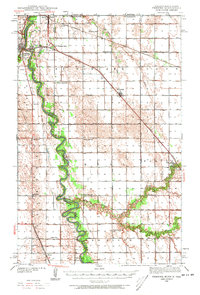
1939 Map of Pembina
USGS Topo · Published 1973About this map
The Red River of the North and the Pembina River converge at the international boundary, defining a landscape shaped by late-1930s border commerce and riverine agriculture. The settlement of Pembina stands prominently near the junction, featuring a regional Airport and the Icelandic Cem, while just across the state line in Minnesota, St Vincent and the border town of Noyes mark the northernmost reach of the United States. This era was defined by a dense network of country schools, such as Joe River Sch and Fleece Sch, which supported the surrounding rural townships of St Vincent and Richardville.
Find a feature on this map
45 named features on this map. Tap any name to fly to it.
Don’t see what you’re looking for? This feature index may not catch every label — zoom into the map to look around manually.
Map Details
Editions of this 1939 Pembina Map
3 editions found
Other maps of this area

1939 · Drayton
USGS Topo · 1:62,500

1939 · Glasston
USGS Topo · 1:62,500

1939 · Pembina
USGS Topo · 1:62,500

1939 · Kennedy
USGS Topo · 1:62,500

1941 · Kennedy
USGS Topo · 1:62,500

1941 · Drayton
USGS Topo · 1:62,500

1941 · Glasston
USGS Topo · 1:62,500

1941 · Hallock
USGS Topo · 1:62,500

1941 · Bathgate
USGS Topo · 1:62,500

1941 · Pembina
USGS Topo · 1:62,500