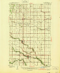
1944 Map of Crystal
USGS Topo · Published 1944About this map
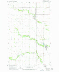
Agricultural settlements and rural schoolhouses define this section of the Red River Valley during the early 1940s. The Great Northern railroad provides the primary industrial corridor, connecting the hubs of Crystal and Hensel P O and Sta to the north and Hoople to the south. This transportation network supported a landscape dotted with numerous local institutions, including St Johns Ch, Vidalin Ch, and St Pauls Ch. The sheer density of named rural schools, such as Scheving Sch, Fisher Sch, and Mount View Sch, illustrates a time before district consolidation when these small schoolhouses served as the social hearts of their respective townships. Drainage is dominated by the meandering paths of The Coulee and the Park River, which cut through the flat prairies of Pembina and Walsh Counties.
Find a feature on this map
37 named features on this map. Tap any name to fly to it.
Don’t see what you’re looking for? This feature index may not catch every label — zoom into the map to look around manually.
Map Details
Editions of this 1944 Crystal Map
This is the sole edition of this map. No revisions or reprints were ever made.
Historical Maps of Hoople Through Time
7 maps found