
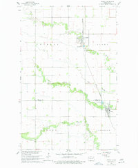
1963 Map of Crystal
USGS Topo · Published 1964About this map
The town of Crystal and the village of Hoople anchor this mid-century survey of the Red River Valley hinterlands. Situated along the Great Northern railroad, these communities served as vital agricultural shipping points for the surrounding townships of Elora, Dundee, and Glenwood. The landscape is defined by the winding paths of the North Branch Park River and the Middle Branch Park River, which cut through the flat plains alongside smaller waterways like Cart Creek and The Coulee. Evidence of early settlement and rural education is preserved in labels for the West Point Cem and the Dundee Sch. The presence of several Sewage Disposal Ponds near the town sites reflects the modernization of local infrastructure during the early 1960s.
Find a feature on this map
16 named features on this map. Tap any name to fly to it.
Don’t see what you’re looking for? This feature index may not catch every label — zoom into the map to look around manually.
Map Details
Editions of this 1963 Crystal Map
2 editions found
Other maps of this area

1944 · Crystal
USGS Topo · 1:62,500

1952 · Thief River Falls
USGS Topo · 1:250,000

1956 · Thief River Falls
USGS Topo · 1:250,000

1957 · Thief River Falls
USGS Topo · 1:250,000

1963 · Crystal SE
USGS Topo · 1:24,000

1963 · Edinburg
USGS Topo · 1:24,000

1963 · Gardar
USGS Topo · 1:24,000

1963 · Nash
USGS Topo · 1:24,000

1963 · Park River
USGS Topo · 1:24,000

1964 · Mountain
USGS Topo · 1:24,000