
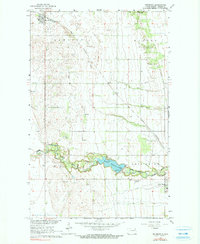
1963 Map of Edinburg
USGS Topo · Published 1964About this map
The Great Northern railroad cuts a diagonal line across the fertile Walsh County plains, connecting the small settlement of Edinburg with the broader grain-shipping network of the Red River Valley. This early 1960s survey documents a landscape defined by organized agricultural tracts within the townships of Lampt On, Dundee, and Kensington. Local life is anchored by community landmarks such as Garfield Ch and Calvary Cem, while the southern reaches of the map highlight a transition from open fields to the wooded riparian corridor of the South Branch Park River. The creation of the Homme Reservoir provides a significant water resource and recreational focal point, evidenced by the establishment of the County Park, Picnic Area, and the Park River Camp. This map effectively captures the mid-century infrastructure of the region, from the Landing Field near Park River to the scattered gravel and sand pits essential for local road building.
Find a feature on this map
25 named features on this map. Tap any name to fly to it.
Don’t see what you’re looking for? This feature index may not catch every label — zoom into the map to look around manually.
Map Details
Editions of this 1963 Edinburg Map
2 editions found
Other maps of this area

1944 · Crystal
USGS Topo · 1:62,500

1952 · Thief River Falls
USGS Topo · 1:250,000

1956 · Thief River Falls
USGS Topo · 1:250,000

1957 · Thief River Falls
USGS Topo · 1:250,000

1963 · Crystal
USGS Topo · 1:24,000

1963 · Pleasant Valley
USGS Topo · 1:24,000

1963 · Gardar
USGS Topo · 1:24,000

1963 · Pisek
USGS Topo · 1:24,000

1963 · Park River
USGS Topo · 1:24,000

1967 · Thief River Falls
USGS Topo · 1:250,000