1970s Maps of Pembina, North Dakota
Explore 2 historic maps of Pembina from the 1970s. These maps offer a rare glimpse into what life looked like during the 1970s — showing old roads, neighborhoods, homes, and landmarks that have changed or disappeared over time.
Whether you're researching your family's past, planning a metal detecting trip, or studying how Pembina's landscape evolved across the 1970s, these high-resolution maps are a powerful tool for exploring the history of this region.
- Focus on a specific era: All maps on this page are from the 1970s, giving you a focused view of this time period.
- See what’s changed: Compare century-old streets, trails, and buildings to today's modern landscape using overlays and satellite layers.
- Research with precision: Use these maps for genealogy, historical research, land use analysis, or educational projects.
- View, download, or print: Maps are fully viewable online in high resolution, and can be downloaded or printed for your own records.
Start exploring Pembina's history through authentic maps from the 1970s. This is your window into the past.
Pembina, ND maps
(2)- 1970 Map of Bathgate NE, 1973 Print
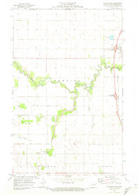 1970 Bathgate NE1973 Print · USGSThe Red River Valley landscape at the Canadian border comes into focus in this early 1970s survey. Genealogists and local historians can trace named river crossings like Hancock Bridge and Trudell Bridge, or locate the Pembina Cem.
 - 1972 Map of Pembina, 1974 Print
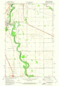 1972 Pembina1974 Print · USGSThe Red River valley at the international border was a bustling transit hub in the early seventies. Genealogists and local historians can trace the border infrastructure at Noyes and locate rural landmarks like Lutheran Cem and St Vincent.2 unique versions available
End of results
Showing maps 1-2 of 2
Top cities near Pembina
Frequently asked questions
- What are the different types of historical maps available for Pembina?
- What is the oldest map of Pembina?
- Where can I purchase historical maps of Pembina for my home or office?
- Where can I download high-res historical maps of Pembina?
- Are there historical topographic maps available for Pembina?
- Is there historical aerial imagery available for Pembina?
- Where are historical maps of Pembina sourced from?