1900s (20th Century) Maps of Rugby, North Dakota
Explore 9 historic maps of Rugby from the 1900s (20th Century). These maps offer a rare glimpse into what life looked like during the 1900s — showing old roads, neighborhoods, homes, and landmarks that have changed or disappeared over time.
Whether you're researching your family's past, planning a metal detecting trip, or studying how Rugby's landscape evolved across the 1900s, these high-resolution maps are a powerful tool for exploring the history of this region.
- Focus on a specific era: All maps on this page are from the 1900s, giving you a focused view of this time period.
- See what’s changed: Compare century-old streets, trails, and buildings to today's modern landscape using overlays and satellite layers.
- Research with precision: Use these maps for genealogy, historical research, land use analysis, or educational projects.
- View, download, or print: Maps are fully viewable online in high resolution, and can be downloaded or printed for your own records.
Start exploring Rugby's history through authentic maps from the 1900s. This is your window into the past.
Rugby, ND maps
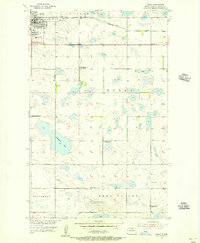
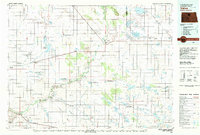
(9)- 1953 Map of Devils Lake, 1968 Print
 1953 Devils Lake1968 Print · USGSNorth Dakota's northern plains are captured here in the mid-fifties, showing a landscape of rail-fed grain elevators and prairie wetlands. Genealogists can locate family landmarks like Rose Hill School, Hurricane Lake Church, and the Turtle Mountain Indian Reservation.3 unique versions available
 - 1954 Map of Tunbridge, 1956 Print
 1954 Tunbridge1956 Print · USGSPierce County farming communities and the prairie landscape appear in high detail during the mid-1950s. Genealogists can locate Tunbridge Ch, Bethel Ch, and rural schoolhouses like Brazil School No 1 alongside the Great Northern railroad.2 unique versions available
 - 1954 Map of Rugby NW, 1956 Print
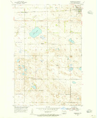
 1954 Rugby NW1956 Print · USGSPierce County prairie life is captured here in the mid-fifties, just northwest of the geographic center of the continent. Genealogists can trace rural school districts like Burke Sch No 3 and locate family landmarks near Goose Lake or the Torgerson hills.
 - 1954 Map of Minot, 1964 Print
 1954 Minot1964 Print · USGSNorth Dakota's northern borderlands are captured here in the mid-fifties, showing a landscape defined by the winding Souris River and the rise of the Turtle Mountains. Genealogists can locate family-named sidings like Hurd Siding and Truro Siding alongside the vital Great Northern rail lines.3 unique versions available
 - 1955 Map of Rugby, 1956 Print
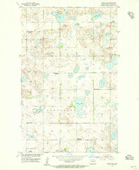
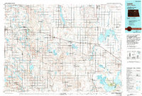
 1955 Rugby1956 Print · USGSRugby and the surrounding North Dakota prairies are captured here in the mid-fifties at the geographical heart of the continent. Genealogists can trace rural school districts and family landmarks like Little Flower Cem and the Lincoln Sch No 1 site.2 unique versions available
 - 1956 Map of Devils Lake
 1956 Devils Lake1956 Print · USGSNorthern North Dakota is shown at a mid-century peak of rail-driven agriculture, where the Soo Line and Great Northern railroads cross the prairie. Trace the borders of the Turtle Mountain Indian Reservation and locate local landmarks like Rose Hill School or Camp Grafton.
 - 1958 Map of Minot
 1958 Minot1958 Print · USGSNorthern North Dakota is shown here during the mid-fifties, dominated by the rail-driven growth of Minot and the surrounding grain-farming prairie. Genealogists can trace family connections to border towns like Westhope or explore the vast reaches of the Turtle Mountains.
 - 1980 Map of Velva
 1980 Velva1980 Print · USGSNorth-central North Dakota comes into focus during the late twentieth century as a landscape of vital wetlands and rail-dependent grain towns. You can trace the Burlington Northern line through Towner or explore the protected prairie potholes of the J Clark Salyer National Wildlife Refuge.
 - 1985 Map of Leeds, 1994 Print
 1985 Leeds1994 Print · USGSBenson and Ramsey counties are shown during the mid-eighties as a patchwork of prairie agriculture and vital wetland habitats. Researchers can locate family roots at Knox Cem, trace the Soo Line rail corridors, or explore the fringes of Devils Lake.
End of results
Showing maps 1-9 of 9
Top cities near Rugby
Frequently asked questions
- What are the different types of historical maps available for Rugby?
- What is the oldest map of Rugby?
- Where can I purchase historical maps of Rugby for my home or office?
- Where can I download high-res historical maps of Rugby?
- Are there historical topographic maps available for Rugby?
- Is there historical aerial imagery available for Rugby?
- Where are historical maps of Rugby sourced from?