1980s Maps of Sioux County, North Dakota
Explore 7 historic maps of Sioux County from the 1980s. These maps offer a rare glimpse into what life looked like during the 1980s — showing old roads, neighborhoods, homes, and landmarks that have changed or disappeared over time.
Whether you're researching your family's past, planning a metal detecting trip, or studying how Sioux County's landscape evolved across the 1980s, these high-resolution maps are a powerful tool for exploring the history of this region.
- Focus on a specific era: All maps on this page are from the 1980s, giving you a focused view of this time period.
- See what’s changed: Compare century-old streets, trails, and buildings to today's modern landscape using overlays and satellite layers.
- Research with precision: Use these maps for genealogy, historical research, land use analysis, or educational projects.
- View, download, or print: Maps are fully viewable online in high resolution, and can be downloaded or printed for your own records.
Start exploring Sioux County's history through authentic maps from the 1980s. This is your window into the past.
Sioux County, ND maps
(7)- 1980 Map of Solen
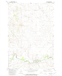 1980 Solen1980 Print · USGSSolen and the Standing Rock Indian Reservation border are captured here in 1980 during a period of rural transition. Genealogists and historians can trace local roots at Sacred Heart Cem, Red Cedar Cem, and the Old Railroad Grade along the Cannonball River.
 - 1980 Map of Breien
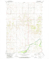 1980 Breien1980 Print · USGSMorton County at the start of the 1980s reveals a quiet landscape shaped by the Cannonball River. Genealogists and historians can trace the Old Railroad Grade past Breien or locate the distinctive War Dance Hill.
 - 1980 Map of Linton
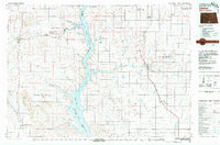 1980 Linton1980 Print · USGSThe Missouri River corridor in the early eighties serves as a backdrop for the sprawling Standing Rock Indian Reservation and Missouri plateau farm towns. Researchers can trace historic railroad routes like the Burlington Northern and find local landmarks such as Fort Yates, Solen, and Winona Flats.
 - 1980 Map of Bell Coulee East
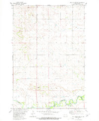 1980 Bell Coulee East1980 Print · USGSThe Cannonball River valley and the Standing Rock Indian Reservation are captured here in the mid-1970s. Trace the rural landscape through landmarks like St Gabriel Cem and a river Ford along the county line.
 - 1980 Map of Elgin
 1980 Elgin1980 Print · USGSNorth Dakota's southern plains come alive in the early eighties as the Standing Rock Indian Reservation meets the Cannonball River. Trace the rail lines serving Elgin and Carson, or locate family-named landmarks like Thompson Butte and Heil.
 - 1980 Map of McIntosh, 1981 Print
 1980 McIntosh1981 Print · USGSThe northern plains of the Standing Rock Indian Reservation are shown here as they appeared in the early 1980s. You can trace the railroad history of Corson County along the Chicago Milwaukee St Paul and Pacific line, connecting settlements like Watauga and Morristown.
 - 1985 Map of Mobridge
 1985 Mobridge1985 Print · USGSCrossing the Missouri River in the mid-1980s, this landscape reveals the intersection of the Standing Rock Indian Reservation and the rising waters of Lake Oahe. Researchers can locate significant historical markers such as Sitting Bulls Grave, St Elizabeth Mission Home, and the Leavenworth Monument.2 unique versions available
End of results
Showing maps 1-7 of 7
Top cities of Sioux County
Frequently asked questions
- What are the different types of historical maps available for Sioux County?
- What is the oldest map of Sioux County?
- Where can I purchase historical maps of Sioux County for my home or office?
- Where can I download high-res historical maps of Sioux County?
- Are there historical topographic maps available for Sioux County?
- Is there historical aerial imagery available for Sioux County?
- Where are historical maps of Sioux County sourced from?