1900s (20th Century) Maps of Donnybrook, North Dakota
Explore 6 historic maps of Donnybrook from the 1900s (20th Century). These maps offer a rare glimpse into what life looked like during the 1900s — showing old roads, neighborhoods, homes, and landmarks that have changed or disappeared over time.
Whether you're researching your family's past, planning a metal detecting trip, or studying how Donnybrook's landscape evolved across the 1900s, these high-resolution maps are a powerful tool for exploring the history of this region.
- Focus on a specific era: All maps on this page are from the 1900s, giving you a focused view of this time period.
- See what’s changed: Compare century-old streets, trails, and buildings to today's modern landscape using overlays and satellite layers.
- Research with precision: Use these maps for genealogy, historical research, land use analysis, or educational projects.
- View, download, or print: Maps are fully viewable online in high resolution, and can be downloaded or printed for your own records.
Start exploring Donnybrook's history through authentic maps from the 1900s. This is your window into the past.
Donnybrook, ND maps
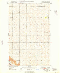
(6)- 1947 Map of Tolley, 1963 Print
 1947 Tolley1963 Print · USGSThe North Dakota prairie near the Mouse River comes to life in this post-war survey of Renville and Ward Counties. Genealogists and local historians can trace rural school locations and family burial sites like Greenbush Cem or St Anthony Cem, while tracking the path of the Great Northern railroad.
 - 1948 Map of Donnybrook
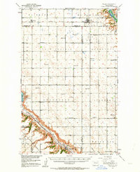
 1948 Donnybrook1948 Print · USGSDonnybrook was a bustling rail hub in the late 1940s where two major lines intersected along the Des Lacs River. Genealogists can locate several rural landmarks including Odd Fellows Cem, Church Hill, and a network of numbered district schools.
 - 1949 Map of Tolley SE
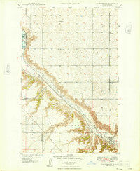
 1949 Tolley SE1949 Print · USGSNorth Dakota's rural heartland is captured here in the late 1940s, showing a landscape of spread-out farmsteads and township life. Genealogists can trace family roots at Greenbush Cem or locate the old White Ash Sch along the Des Lacs River.
 - 1950 Map of Tolley
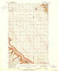 1950 Tolley1950 Print · USGSRenville and Ward Counties are captured here mid-century, showcasing the vital rail-and-river economy of the northern plains. Local researchers can trace the locations of rural schoolhouses and family burial sites like Trinity Cem and Odd Fellows Cem near Tolley and Donnybrook.
 - 1954 Map of Minot, 1964 Print
 1954 Minot1964 Print · USGSNorth Dakota's northern borderlands are captured here in the mid-fifties, showing a landscape defined by the winding Souris River and the rise of the Turtle Mountains. Genealogists can locate family-named sidings like Hurd Siding and Truro Siding alongside the vital Great Northern rail lines.3 unique versions available
 - 1958 Map of Minot
 1958 Minot1958 Print · USGSNorthern North Dakota is shown here during the mid-fifties, dominated by the rail-driven growth of Minot and the surrounding grain-farming prairie. Genealogists can trace family connections to border towns like Westhope or explore the vast reaches of the Turtle Mountains.
End of results
Showing maps 1-6 of 6
Top cities near Donnybrook
- Kenmare historical maps
- Berthold historical maps
- Carpio historical maps
- Tolley historical maps
- Baden historical maps
Frequently asked questions
- What are the different types of historical maps available for Donnybrook?
- What is the oldest map of Donnybrook?
- Where can I purchase historical maps of Donnybrook for my home or office?
- Where can I download high-res historical maps of Donnybrook?
- Are there historical topographic maps available for Donnybrook?
- Is there historical aerial imagery available for Donnybrook?
- Where are historical maps of Donnybrook sourced from?