1940s Maps of Adams County, Ohio
Explore 6 historic maps of Adams County from the 1940s. These maps offer a rare glimpse into what life looked like during the 1940s — showing old roads, neighborhoods, homes, and landmarks that have changed or disappeared over time.
Whether you're researching your family's past, planning a metal detecting trip, or studying how Adams County's landscape evolved across the 1940s, these high-resolution maps are a powerful tool for exploring the history of this region.
- Focus on a specific era: All maps on this page are from the 1940s, giving you a focused view of this time period.
- See what’s changed: Compare century-old streets, trails, and buildings to today's modern landscape using overlays and satellite layers.
- Research with precision: Use these maps for genealogy, historical research, land use analysis, or educational projects.
- View, download, or print: Maps are fully viewable online in high resolution, and can be downloaded or printed for your own records.
Start exploring Adams County's history through authentic maps from the 1940s. This is your window into the past.
Adams County, OH maps
(6)- 1944 Map of Hillsboro
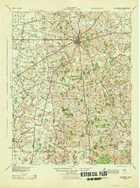 1944 Hillsboro1944 Print · USGSHighland County is documented here during the mid-forties, showing the vital rail junction at Hillsboro and a dense network of rural schools. Trace ancestral roots through localized landmarks like Brier College Sch, Mowrystown, and Millers Chapel Ch.
 - 1947 Map of Columbus, 1948 Print
 1947 Columbus1948 Print · USGSCentral Ohio in the late 1940s is captured in this survey, showing the post-war transition of its rail hubs and military airfield expansions. Genealogists and historians can trace the paths of the Ohio Canal, the Pennsylvania RR lines, and the Camp Sherman Military Reservation.
 - 1949 Map of Vanceburg, 1960 Print
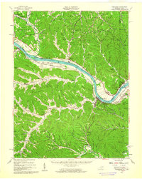 1949 Vanceburg1960 Print · USGSThe Ohio River valley and the rugged hills of Lewis County are captured here just after the war. Local historians can trace family roots through numerous country landmarks like Beasley Fork Chapel, Aills Cem, and the County Infirmary.
 - 1949 Map of Buena Vista, 1964 Print
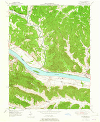
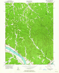 1949 Buena Vista1964 Print · USGSThe Ohio River borderlands of the late 1940s reveal a landscape of river navigation and forest management. Researchers can trace riverside life at Rome (Stout PO), locate the Twin Creek Lookout Tower, and find rural congregations like Aills Chapel.
 - 1949 Map of Vanceburg, 1964 Print
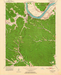 1949 Vanceburg1964 Print · USGSVanceburg and the surrounding hollows of Lewis County are captured here just after the war, showing the deep intersection of river, rail, and ridge life. Genealogists can locate family landmarks such as Holly Cem, the Lewis County Infirmary, and Holly Hill Ch.4 unique versions available
 - 1949 Map of Concord, 1965 Print
 1949 Concord1965 Print · USGSThe Ohio River valley in the late 1940s reveals a landscape of river-and-rail industry along the Lewis County border. Trace the vanished stops at Rome Sta and Chalkley Sta, or find rural landmarks like Beasley Fork Chapel and Martin (Queens PO).
End of results
Showing maps 1-6 of 6
Top cities of Adams County
- West Union historical maps
- Manchester historical maps
- Peebles historical maps
- Winchester historical maps
- Seaman historical maps
- Cherry Fork historical maps
Frequently asked questions
- What are the different types of historical maps available for Adams County?
- What is the oldest map of Adams County?
- Where can I purchase historical maps of Adams County for my home or office?
- Where can I download high-res historical maps of Adams County?
- Are there historical topographic maps available for Adams County?
- Is there historical aerial imagery available for Adams County?
- Where are historical maps of Adams County sourced from?