1950s Maps of Adams County, Ohio
Explore 6 historic maps of Adams County from the 1950s. These maps offer a rare glimpse into what life looked like during the 1950s — showing old roads, neighborhoods, homes, and landmarks that have changed or disappeared over time.
Whether you're researching your family's past, planning a metal detecting trip, or studying how Adams County's landscape evolved across the 1950s, these high-resolution maps are a powerful tool for exploring the history of this region.
- Focus on a specific era: All maps on this page are from the 1950s, giving you a focused view of this time period.
- See what’s changed: Compare century-old streets, trails, and buildings to today's modern landscape using overlays and satellite layers.
- Research with precision: Use these maps for genealogy, historical research, land use analysis, or educational projects.
- View, download, or print: Maps are fully viewable online in high resolution, and can be downloaded or printed for your own records.
Start exploring Adams County's history through authentic maps from the 1950s. This is your window into the past.
Adams County, OH maps
(6)- 1951 Map of Vanceburg
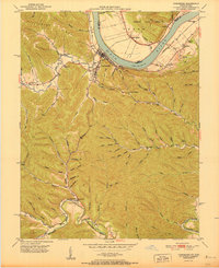 1951 Vanceburg1951 Print · USGSVanceburg and the surrounding Lewis County hills are captured here in the early fifties, showing the river-and-rail economy along the Ohio River. Researchers can trace old family sites and rural infrastructure, from the Lewis County Infirmary to local landmarks like Evans Chapel and the Rock Run Sch.
 - 1951 Map of Buena Vista
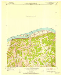
 1951 Buena Vista1951 Print · USGSThe Ohio River borderlands at the start of the 1950s show a landscape of deep timbered hollows and river navigation. Researchers can trace rural life through the locations of Dam No 32, the Twin Creek Mission, and the Rome (Stout PO) settlement.
 - 1951 Map of Concord
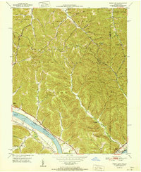
 1951 Concord1951 Print · USGSThe riverfront communities of Lewis County and Adams County thrive along the Ohio during the early post-war era. Genealogists and local historians can trace family locations near Concord, identify the Stout Post Office, or find rural landmarks like Beasley Fork Chapel and the Carrs School.2 unique versions available
 - 1952 Map of Maysville East, 1953 Print
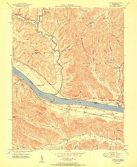
 1952 Maysville East1953 Print · USGSThe Ohio River valley near the Mason County line is captured here in the early fifties, showing the vital river-and-rail corridor. Researchers can trace the riverfront development of Maysville or locate landmarks near Sand Hill and the Chesapeake and Ohio railroad.
 - 1952 Map of Manchester Islands, 1954 Print
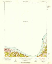
 1952 Manchester Islands1954 Print · USGSThe Ohio River shoreline and the timbered heights of Lewis County come alive in this early 1950s survey. Researchers can trace family-named landmarks and rural hubs like Trinity Station, Covedale, and the remote Sulphur Knob Lookout Tower.
 - 1957 Map of Huntington, 1966 Print
 1957 Huntington1966 Print · USGSThe industrial heart of the Ohio River valley is captured here in the mid-sixties, showing the growth of Huntington and Ashland. Researchers can trace the extensive rail networks of the Chesapeake and Ohio RR and locate sites like the Chief Cornstalk Hunting Ground.3 unique versions available
End of results
Showing maps 1-6 of 6
Top cities of Adams County
- West Union historical maps
- Manchester historical maps
- Peebles historical maps
- Winchester historical maps
- Seaman historical maps
- Cherry Fork historical maps
Frequently asked questions
- What are the different types of historical maps available for Adams County?
- What is the oldest map of Adams County?
- Where can I purchase historical maps of Adams County for my home or office?
- Where can I download high-res historical maps of Adams County?
- Are there historical topographic maps available for Adams County?
- Is there historical aerial imagery available for Adams County?
- Where are historical maps of Adams County sourced from?