1960s Maps of Ripley, Ohio
Explore 3 historic maps of Ripley from the 1960s. These maps offer a rare glimpse into what life looked like during the 1960s — showing old roads, neighborhoods, homes, and landmarks that have changed or disappeared over time.
Whether you're researching your family's past, planning a metal detecting trip, or studying how Ripley's landscape evolved across the 1960s, these high-resolution maps are a powerful tool for exploring the history of this region.
- Focus on a specific era: All maps on this page are from the 1960s, giving you a focused view of this time period.
- See what’s changed: Compare century-old streets, trails, and buildings to today's modern landscape using overlays and satellite layers.
- Research with precision: Use these maps for genealogy, historical research, land use analysis, or educational projects.
- View, download, or print: Maps are fully viewable online in high resolution, and can be downloaded or printed for your own records.
Start exploring Ripley's history through authentic maps from the 1960s. This is your window into the past.
Ripley, OH maps
(3)- 1960 Map of Huntington
 1960 Huntington1960 Print · USGSThe tri-state river valley thrived in the late fifties as a hub of heavy industry and Appalachian rail transit. Genealogists and historians can trace the connection between river towns like Ashland and Portsmouth or locate family homesteads near Coleman Ridge.
 - 1961 Map of Maysville West, 1963 Print
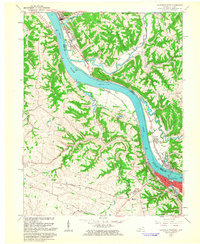 1961 Maysville West1963 Print · USGSThe Ohio River dominates this early 1960s landscape, connecting the bustling riverfront of Maysville with the quiet ridges of Union. Genealogists can trace family names through Maplewood Cem, Fitchs Chapel Cem, and the Lawrence Creek Ch.4 unique versions available
 - 1961 Map of Russellville, 1963 Print
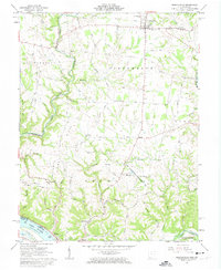 1961 Russellville1963 Print · USGSBrown County, Ohio, is captured in the early sixties as a landscape of ridge-top farms and deep creek hollows. Genealogists can trace family footprints at Linwood Cem and the John Rankin Home, or locate rural landmarks like the Covered Bridge and Redoak Ch.3 unique versions available
End of results
Showing maps 1-3 of 3
Top cities near Ripley
- Maysville historical maps
- Georgetown historical maps
- Manchester historical maps
- Aberdeen historical maps
- Augusta historical maps
- Winchester historical maps
See more
Top neighborhoods of Ripley
Frequently asked questions
- What are the different types of historical maps available for Ripley?
- What is the oldest map of Ripley?
- Where can I purchase historical maps of Ripley for my home or office?
- Where can I download high-res historical maps of Ripley?
- Are there historical topographic maps available for Ripley?
- Is there historical aerial imagery available for Ripley?
- Where are historical maps of Ripley sourced from?