1960s Maps of Butler County, Ohio
Explore 11 historic maps of Butler County from the 1960s. These maps offer a rare glimpse into what life looked like during the 1960s — showing old roads, neighborhoods, homes, and landmarks that have changed or disappeared over time.
Whether you're researching your family's past, planning a metal detecting trip, or studying how Butler County's landscape evolved across the 1960s, these high-resolution maps are a powerful tool for exploring the history of this region.
- Focus on a specific era: All maps on this page are from the 1960s, giving you a focused view of this time period.
- See what’s changed: Compare century-old streets, trails, and buildings to today's modern landscape using overlays and satellite layers.
- Research with precision: Use these maps for genealogy, historical research, land use analysis, or educational projects.
- View, download, or print: Maps are fully viewable online in high resolution, and can be downloaded or printed for your own records.
Start exploring Butler County's history through authentic maps from the 1960s. This is your window into the past.
Butler County, OH maps
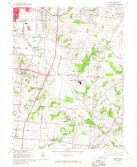
(11)- 1960 Map of College Corner, 1961 Print
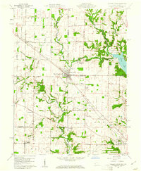 1960 College Corner1961 Print · USGSCollege Corner sits at the crossroads of Indiana and Ohio at the start of the 1960s, a landscape defined by intersecting railroads and state lines. Genealogists can trace family roots through College Corner Cemetery, Hopewell Ch, and the rural settlement of Charlottesville.4 unique versions available
 - 1961 Map of Oxford, 1962 Print
 1961 Oxford1962 Print · USGSButler and Preble counties come into focus during the early sixties, showing the expansion of Miami University alongside traditional farmsteads. Researchers can trace the Pennsylvania rail corridor or locate ancestral sites like Beechwood Cem and Morning Sun.4 unique versions available
 - 1961 Map of West Elkton, 1962 Print
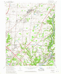
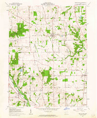 1961 West Elkton1962 Print · USGSSouthwestern Ohio at the start of the sixties reveals a landscape of established farmsteads and quiet creek valleys. Genealogists can locate family landmarks like Fairmound Cem, The Little Family Ch, and the old rail stop at Collinsville.2 unique versions available
 - 1965 Map of Franklin, 1967 Print
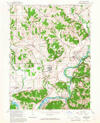
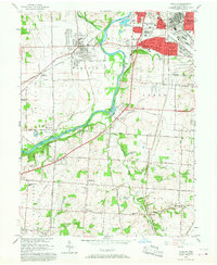
 1965 Franklin1967 Print · USGSMiddletown and Franklin thrive along the river and rail corridors of the Miami Valley in the mid-1960s. Genealogists and researchers can trace local landmarks like Wood Hill Cemetery, Stettler Ch, and the sprawling Mound Laboratory (AEC) complex.5 unique versions available
 - 1965 Map of Monroe, 1967 Print
 1965 Monroe1967 Print · USGSButler and Warren Counties are seen during a period of rapid development in the mid-sixties. Local researchers can trace family roots at Mound Cemetery, locate the old Beedles Station, or study the footprint of the Lebanon Correctional Institution.5 unique versions available
 - 1965 Map of Greenhills, 1968 Print
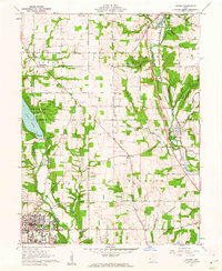
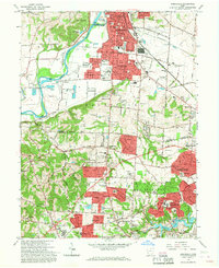 1965 Greenhills1968 Print · USGSGreater Cincinnati's northern suburbs were rapidly evolving in the mid-sixties as post-war growth transformed the Butler and Hamilton County line. Genealogists and local historians can trace family-named sites like Huston Cem and landmarks such as St Francis Seminary and Lake Gloria.4 unique versions available
 - 1965 Map of Shandon, 1968 Print
 1965 Shandon1968 Print · USGSThe Butler and Hamilton County borderlands were defined in the mid-1960s by a unique mix of industrial facilities and deep-rooted rural settlements. Genealogists can trace family landmarks like Shaker Cem and Scott Cem or locate the sprawling U S Reservation (Atomic Energy Commission) facility at Fernald.3 unique versions available
 - 1965 Map of Glendale, 1968 Print
 1965 Glendale1968 Print · USGSThe northern Cincinnati suburbs and Butler County borderlands were rapidly modernizing in the mid-sixties as highways met historic rail junctions. Genealogists and local historians can trace family plots at Oak Hill Cemetery and locate older rail-stop communities like Rialto, Port Union, and West Chester Sta.4 unique versions available
 - 1965 Map of Mason, 1968 Print
 1965 Mason1968 Print · USGSWarren and Hamilton counties are shown in the mid-sixties as the suburban corridor north of Cincinnati began to accelerate. Researchers can trace the massive U S Reservation Voice of America site, the old crossroads at Sixteen Mile Stand, and landmarks like the Radio Tower (WLW).4 unique versions available
 - 1965 Map of Hamilton, 1968 Print
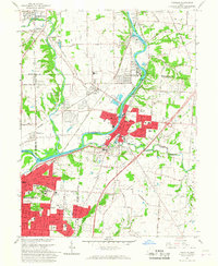
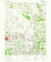
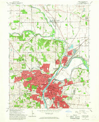 1965 Hamilton1968 Print · USGSHamilton and the Great Miami River valley are shown here in the mid-sixties during a period of significant suburban and industrial growth. Genealogists can trace family plots in Greenwood Cemetery or locate long-standing institutions like Taft High Sch and the Fort Hamilton Monument.4 unique versions available
 - 1966 Map of Trenton, 1968 Print
 1966 Trenton1968 Print · USGSThe industrial corridor of the Great Miami River valley is captured here in the mid-1960s as suburban growth met rural township life. Researchers can locate family sites and landmarks like Miltonville Cem, Babeck Sch, and the rail lines of the Baltimore and Ohio.5 unique versions available
End of results
Showing maps 1-11 of 11
Top cities of Butler County
- Hamilton historical maps
- Middletown historical maps
- Fairfield historical maps
- Lemon Township historical maps
- Trenton historical maps
- Ross Township historical maps
See more
Frequently asked questions
- What are the different types of historical maps available for Butler County?
- What is the oldest map of Butler County?
- Where can I purchase historical maps of Butler County for my home or office?
- Where can I download high-res historical maps of Butler County?
- Are there historical topographic maps available for Butler County?
- Is there historical aerial imagery available for Butler County?
- Where are historical maps of Butler County sourced from?