1950s Maps of Clermont County, Ohio
Explore 17 historic maps of Clermont County from the 1950s. These maps offer a rare glimpse into what life looked like during the 1950s — showing old roads, neighborhoods, homes, and landmarks that have changed or disappeared over time.
Whether you're researching your family's past, planning a metal detecting trip, or studying how Clermont County's landscape evolved across the 1950s, these high-resolution maps are a powerful tool for exploring the history of this region.
- Focus on a specific era: All maps on this page are from the 1950s, giving you a focused view of this time period.
- See what’s changed: Compare century-old streets, trails, and buildings to today's modern landscape using overlays and satellite layers.
- Research with precision: Use these maps for genealogy, historical research, land use analysis, or educational projects.
- View, download, or print: Maps are fully viewable online in high resolution, and can be downloaded or printed for your own records.
Start exploring Clermont County's history through authentic maps from the 1950s. This is your window into the past.
Clermont County, OH maps
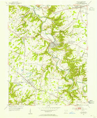
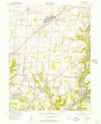
(17)- 1953 Map of Laurel, 1955 Print
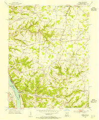 1953 Laurel1955 Print · USGSClermont County's riverfront and upland hamlets are captured here in the early fifties, showing the rural character of the Ohio River valley. Researchers can locate the Chesapeake and Ohio rail line and historic community hubs like Point Pleasant, Laurel, and the Monroe Sch.
 - 1953 Map of Withamsville, 1955 Print
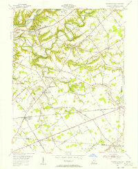
 1953 Withamsville1955 Print · USGSThe Ohio River valley in the early fifties shows a landscape of ridge-top settlements and active rail lines. Genealogists can trace family sites near Clough Chapel, Asbury Cem, and early schools like Township Sch.
 - 1953 Map of Bethel, 1955 Print
 1953 Bethel1955 Print · USGSClermont and Brown County rural life is captured here in the early fifties, centered on the growing village of Bethel. Genealogists can trace family landmarks like Lakin Chapel, Mt Olive, and the Rose Hill Cem near Feesburg.
 - 1953 Map of Goshen, 1955 Print
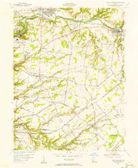
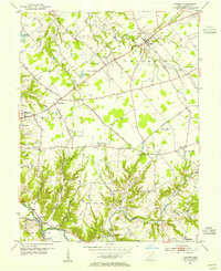 1953 Goshen1955 Print · USGSClermont County in the early fifties shows a rural landscape of small townships and family farms. Local historians can trace the paths of the Norfolk and Western railroad and locate landmarks like the Covered Bridge and Pleasant Hill Ch.
 - 1953 Map of Batavia, 1955 Print
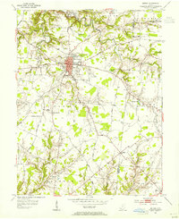
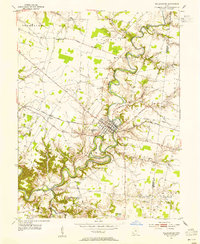
 1953 Batavia1955 Print · USGSClermont County in the early fifties shows a rural landscape transitioning toward modern growth along the East Fork Little Miami River. Researchers can find historic family landmarks like Stonelick Cem, the village of Batavia, and a local Covered Bridge.
 - 1953 Map of New Richmond, 1955 Print
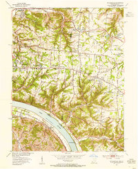
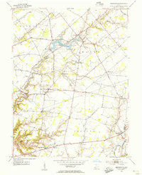
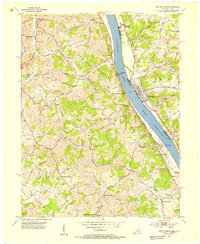 1953 New Richmond1955 Print · USGSThe Ohio River valley in the early fifties showcases a landscape defined by riverside rail commerce and dispersed rural hamlets. Local historians can trace the foundations of New Richmond alongside community landmarks like Gubser Mill, Twelvemile Ch, and Lock and Dam 35.3 unique versions available
 - 1953 Map of Felicity, 1955 Print
 1953 Felicity1955 Print · USGSThe Ohio River valley at the mid-century shows the river-and-rail economy of Clermont and Bracken counties. Researchers can trace the Chesapeake and Ohio line through Augusta or locate sites like Utopia, Boudes Ferry, and Mt Zion Ch.2 unique versions available
 - 1953 Map of Newtonsville, 1955 Print
 1953 Newtonsville1955 Print · USGSClermont County's rural landscape is captured here in the early fifties, just as new recreation areas like Stonelick Lake were being established. Local historians can trace the foundations of old crossroads settlements like Newtonsville, Edenton, and Pringle Corners, alongside numerous family burial grounds including Monterey Cem.2 unique versions available
 - 1953 Map of Williamsburg, 1955 Print
 1953 Williamsburg1955 Print · USGSClermont County's rural townships are shown here in the early fifties, centering on the river bends of Williamsburg. Genealogists and researchers can trace family landmarks like Hennings Mills, Alpine Sch, and the Covered Bridge over the river.2 unique versions available
 - 1953 Map of Moscow, 1955 Print
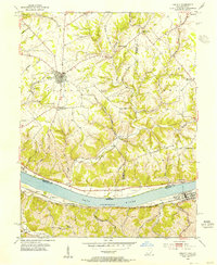
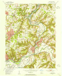
 1953 Moscow1955 Print · USGSThe Ohio River valley in the early fifties reveals a landscape defined by riverside rail travel and upland farming along the Ohio-Kentucky border. Genealogists can trace family sites at Vesper Cem and Flat Rock Ch, or locate old river works at Lock and Dam No 34.2 unique versions available
 - 1953 Map of Madeira, 1955 Print
 1953 Madeira1955 Print · USGSHamilton and Clermont counties meet along the Little Miami River during the mid-century suburban expansion of the Cincinnati area. Researchers can trace the grounds of the Sacred Heart Novitiate, the Pennsylvania Railroad corridor, and local landmarks like Lake Isabella.
 - 1953 Map of Cincinnati, 1965 Print
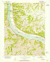
 1953 Cincinnati1965 Print · USGSThe Ohio River valley and the industrial heartland of Indiana and Ohio are captured here during the mid-century peak of rail and river commerce. Genealogists and historians can trace connections between Cincinnati and outlying military sites like Camp Atterbury and Bakalar AFB.3 unique versions available
 - 1955 Map of South Lebanon, 1956 Print
 1955 South Lebanon1956 Print · USGSWarren and Clermont Counties are captured in the mid-fifties, showing the industrial pulse of the Little Miami River valley alongside quiet farming hamlets. Trace family roots at Deerfield Cem, locate the old Township Sch, or explore the rail hubs at Middletown Junction and Morrow.4 unique versions available
 - 1955 Map of Mason, 1956 Print
 1955 Mason1956 Print · USGSSouthwestern Ohio was entering a period of suburban expansion in the mid-fifties while maintaining its vital river and rail corridors. Trace the massive Voice of America transmitter site and local landmarks like Kings Mills and Gate of Heaven Cemetery.
 - 1955 Map of Pleasant Plain, 1956 Print
 1955 Pleasant Plain1956 Print · USGSWarren and Clermont counties are shown in the mid-fifties as a landscape of rural hamlets and winding river forks. Family historians can trace numerous rural sites like Ruhyan Cem, Leather Ear Ch, and the Baltimore and Ohio RR corridor.2 unique versions available
 - 1956 Map of Louisville, 1971 Print
 1956 Louisville1971 Print · USGSThe Ohio River valley and the Kentucky Bluegrass are captured here during a period of rapid mid-century growth and industrial activity. Genealogists and historians can trace rail-centered towns and military land use at Fort Knox and the Jefferson Proving Ground.2 unique versions available
 - 1957 Map of Cincinnati
 1957 Cincinnati1957 Print · USGSThe Ohio River valley and its surrounding highlands thrived during the mid-fifties industrial peak, centered on the bustling Cincinnati and Dayton metropolitan hubs. Researchers can trace the extensive rail networks and military sites like Wright-Patterson AFB and Camp Atterbury.
End of results
Showing maps 1-17 of 17
Top cities of Clermont County
Frequently asked questions
- What are the different types of historical maps available for Clermont County?
- What is the oldest map of Clermont County?
- Where can I purchase historical maps of Clermont County for my home or office?
- Where can I download high-res historical maps of Clermont County?
- Are there historical topographic maps available for Clermont County?
- Is there historical aerial imagery available for Clermont County?
- Where are historical maps of Clermont County sourced from?