Old Maps of Clermont County, Ohio for Genealogy
Trace your family roots with 140 historic maps of Clermont County. These high-res maps reveal old neighborhoods, homesites, landmarks, and streets — helping you uncover where your ancestors lived and how the area evolved over time.
- Explore historic neighborhoods: Identify where your relatives may have lived in the 1800s or 1900s.
- Compare maps over time: Trace the changes in streets, buildings, and landmarks for multi-generational research.
- Perfect for genealogy & ancestry research: Used by family historians and researchers to map out lineage and migration.
These maps are an incredible resource for exploring your personal connection to Clermont County's past.
Clermont County, OH maps
(140)- 1898 Map of East Cincinnati, 1964 Print
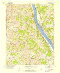
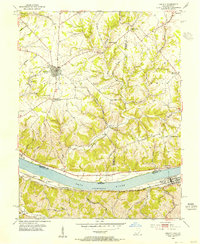
 1898 East Cincinnati1964 Print · USGSGreater Cincinnati and Northern Kentucky emerge as a bustling riverfront and rail hub at the turn of the century. Genealogists and historians can trace the early footprints of Coney Island Resort, the Longview Asylum, and the Cincinnati Waterworks.
 - 1904 Map of Mason, 1958 Print
 1904 Mason1958 Print · USGSSouthwestern Ohio at the turn of the century is a landscape of thriving canal-era towns and expanding rail corridors. Genealogists and researchers can trace the early layouts of Union Village, Shaker Village, and the industrial riverside at Kings Mills.
 - 1906 Map of Mason, 1939 Print
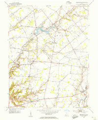
 1906 Mason1939 Print · USGSWarren and Butler counties are shown here in the first decade of the 1900s, when electric railways were transforming rural life. Genealogists can trace family roots through old hubs like Union Village, Kings Mills, and Amanda Excello P O.2 unique versions available
 - 1907 Map of Blanchester
 1907 Blanchester1907 Print · USGSClinton County at the dawn of the twentieth century was a landscape of well-connected rail towns and country parishes. Genealogists can trace family roots through numerous landmarks like Macedonia Chapel, Dutch School, and the Childrens Home near Wilmington.3 unique versions available
 - 1914 Map of East Cincinnati
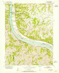
 1914 East Cincinnati1914 Print · USGSThe eastern Cincinnati suburbs and Northern Kentucky riverfront come alive in this pre-war survey of industrial and residential growth. Genealogists can trace family footprints near the St Aloysius Orphan Asylum, Alpine Bell School, or the Covington Reservoirs.4 unique versions available
 - 1914 Map of Batavia
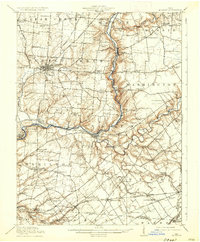
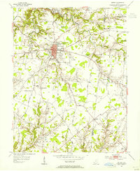
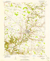
 1914 Batavia1914 Print · USGSClermont County at the start of the Great War shows a landscape connected by steam and electric rail. Genealogists can locate family landmarks like Spread Eagle School, Mt Zion Church, and the winding East Fork Little Miami River.
 - 1914 Map of Morrow, 1963 Print
 1914 Morrow1963 Print · USGSWarren County in the years before the Great War is a landscape of thriving river towns and busy rail junctions. Genealogists and historians can trace family locations through numerous rural schoolhouses like Chestnut Ridge School or landmarks like Fort Ancient and Stubbs Mill.
 - 1916 Map of Batavia
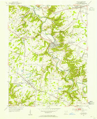
 1916 Batavia1916 Print · USGSClermont County's river valleys and electric railway networks are frozen in time just before the First World War. Researchers can trace dozens of rural school sites like Zionsville School and follow the old Chillicothe Road through Batavia.4 unique versions available
 - 1916 Map of Morrow, 1936 Print
 1916 Morrow1936 Print · USGSWarren County at the start of the Great War is a landscape of thriving river towns and dense rural school districts. Genealogists can locate family-named schools and early settlements like Harveysburg, Maineville, and the landmark Fort Ancient.2 unique versions available
 - 1917 Map of Sardinia, 1946 Print
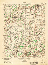
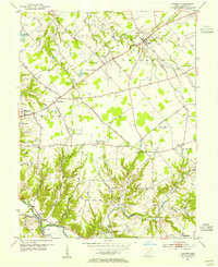
 1917 Sardinia1946 Print · USGSSouthwestern Ohio at the close of the Great War era reveals a landscape of thriving rural schoolhouses and bustling railroad junctions. Genealogists can trace family footprints across dozens of local districts like Richland School or near the Ursuline Convent and Mount Orab.
 - 1929 Map of Alexandria
 1929 Alexandria1929 Print · USGSNorthern Kentucky and the Ohio River border appear here in the late twenties as a bustling landscape of ridge-top farms and river-valley rail towns. Genealogists can trace family roots through numerous local landmarks like Oak Island Ch, Grants Lick, and the many rural schools such as Carthage Sch.
 - 1931 Map of Felicity
 1931 Felicity1931 Print · USGSClermont County's riverfront and rolling uplands are captured here in the early thirties as a network of small schoolhouses and rail lines defined rural life. Researchers can trace the path of the Cincinnati Georgetown and Portsmouth RR or locate family sites near Felicity, Utopia, and Lock 34.2 unique versions available
 - 1936 Map of Alexandria
 1936 Alexandria1936 Print · USGSNorthern Kentucky and the Ohio River valley appear here in the mid-1930s, showing a landscape defined by sharp river bends and rural rail stops. Researchers can trace historic schools and parish centers like Sts Peter and Paul Sch, the winding Licking Valley Highway, and the riverside operations at Gubser Mill.2 unique versions available
 - 1944 Map of Sardinia
 1944 Sardinia1944 Print · USGSSouthwestern Ohio during the Second World War was a landscape of dense rail networks and dozens of small school districts. Genealogists can trace family footprints through numerous rural landmarks like Richland Sch, Bardwell Corners, and the historic Ursuline Convent.
 - 1947 Map of Columbus, 1948 Print
 1947 Columbus1948 Print · USGSCentral Ohio in the late 1940s is captured in this survey, showing the post-war transition of its rail hubs and military airfield expansions. Genealogists and historians can trace the paths of the Ohio Canal, the Pennsylvania RR lines, and the Camp Sherman Military Reservation.
 - 1953 Map of Laurel, 1955 Print
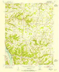 1953 Laurel1955 Print · USGSClermont County's riverfront and upland hamlets are captured here in the early fifties, showing the rural character of the Ohio River valley. Researchers can locate the Chesapeake and Ohio rail line and historic community hubs like Point Pleasant, Laurel, and the Monroe Sch.
 - 1953 Map of Withamsville, 1955 Print
 1953 Withamsville1955 Print · USGSThe Ohio River valley in the early fifties shows a landscape of ridge-top settlements and active rail lines. Genealogists can trace family sites near Clough Chapel, Asbury Cem, and early schools like Township Sch.
 - 1953 Map of Bethel, 1955 Print
 1953 Bethel1955 Print · USGSClermont and Brown County rural life is captured here in the early fifties, centered on the growing village of Bethel. Genealogists can trace family landmarks like Lakin Chapel, Mt Olive, and the Rose Hill Cem near Feesburg.
 - 1953 Map of Goshen, 1955 Print
 1953 Goshen1955 Print · USGSClermont County in the early fifties shows a rural landscape of small townships and family farms. Local historians can trace the paths of the Norfolk and Western railroad and locate landmarks like the Covered Bridge and Pleasant Hill Ch.
 - 1953 Map of Batavia, 1955 Print
 1953 Batavia1955 Print · USGSClermont County in the early fifties shows a rural landscape transitioning toward modern growth along the East Fork Little Miami River. Researchers can find historic family landmarks like Stonelick Cem, the village of Batavia, and a local Covered Bridge.
 - 1953 Map of New Richmond, 1955 Print
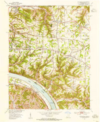
 1953 New Richmond1955 Print · USGSThe Ohio River valley in the early fifties showcases a landscape defined by riverside rail commerce and dispersed rural hamlets. Local historians can trace the foundations of New Richmond alongside community landmarks like Gubser Mill, Twelvemile Ch, and Lock and Dam 35.3 unique versions available
 - 1953 Map of Felicity, 1955 Print
 1953 Felicity1955 Print · USGSThe Ohio River valley at the mid-century shows the river-and-rail economy of Clermont and Bracken counties. Researchers can trace the Chesapeake and Ohio line through Augusta or locate sites like Utopia, Boudes Ferry, and Mt Zion Ch.2 unique versions available
 - 1953 Map of Newtonsville, 1955 Print
 1953 Newtonsville1955 Print · USGSClermont County's rural landscape is captured here in the early fifties, just as new recreation areas like Stonelick Lake were being established. Local historians can trace the foundations of old crossroads settlements like Newtonsville, Edenton, and Pringle Corners, alongside numerous family burial grounds including Monterey Cem.2 unique versions available
 - 1953 Map of Williamsburg, 1955 Print
 1953 Williamsburg1955 Print · USGSClermont County's rural townships are shown here in the early fifties, centering on the river bends of Williamsburg. Genealogists and researchers can trace family landmarks like Hennings Mills, Alpine Sch, and the Covered Bridge over the river.2 unique versions available
 - 1953 Map of Moscow, 1955 Print
 1953 Moscow1955 Print · USGSThe Ohio River valley in the early fifties reveals a landscape defined by riverside rail travel and upland farming along the Ohio-Kentucky border. Genealogists can trace family sites at Vesper Cem and Flat Rock Ch, or locate old river works at Lock and Dam No 34.2 unique versions available
Showing maps 1-25 of 140
Top cities of Clermont County
Frequently asked questions
- What are the different types of historical maps available for Clermont County?
- What is the oldest map of Clermont County?
- Where can I purchase historical maps of Clermont County for my home or office?
- Where can I download high-res historical maps of Clermont County?
- Are there historical topographic maps available for Clermont County?
- Is there historical aerial imagery available for Clermont County?
- Where are historical maps of Clermont County sourced from?