1910s Maps of Clermont County, Ohio
Explore 6 historic maps of Clermont County from the 1910s. These maps offer a rare glimpse into what life looked like during the 1910s — showing old roads, neighborhoods, homes, and landmarks that have changed or disappeared over time.
Whether you're researching your family's past, planning a metal detecting trip, or studying how Clermont County's landscape evolved across the 1910s, these high-resolution maps are a powerful tool for exploring the history of this region.
- Focus on a specific era: All maps on this page are from the 1910s, giving you a focused view of this time period.
- See what’s changed: Compare century-old streets, trails, and buildings to today's modern landscape using overlays and satellite layers.
- Research with precision: Use these maps for genealogy, historical research, land use analysis, or educational projects.
- View, download, or print: Maps are fully viewable online in high resolution, and can be downloaded or printed for your own records.
Start exploring Clermont County's history through authentic maps from the 1910s. This is your window into the past.
Clermont County, OH maps
(6)- 1914 Map of East Cincinnati
 1914 East Cincinnati1914 Print · USGSThe eastern Cincinnati suburbs and Northern Kentucky riverfront come alive in this pre-war survey of industrial and residential growth. Genealogists can trace family footprints near the St Aloysius Orphan Asylum, Alpine Bell School, or the Covington Reservoirs.4 unique versions available
 - 1914 Map of Batavia
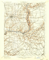
 1914 Batavia1914 Print · USGSClermont County at the start of the Great War shows a landscape connected by steam and electric rail. Genealogists can locate family landmarks like Spread Eagle School, Mt Zion Church, and the winding East Fork Little Miami River.
 - 1914 Map of Morrow, 1963 Print
 1914 Morrow1963 Print · USGSWarren County in the years before the Great War is a landscape of thriving river towns and busy rail junctions. Genealogists and historians can trace family locations through numerous rural schoolhouses like Chestnut Ridge School or landmarks like Fort Ancient and Stubbs Mill.
 - 1916 Map of Batavia
 1916 Batavia1916 Print · USGSClermont County's river valleys and electric railway networks are frozen in time just before the First World War. Researchers can trace dozens of rural school sites like Zionsville School and follow the old Chillicothe Road through Batavia.4 unique versions available
 - 1916 Map of Morrow, 1936 Print
 1916 Morrow1936 Print · USGSWarren County at the start of the Great War is a landscape of thriving river towns and dense rural school districts. Genealogists can locate family-named schools and early settlements like Harveysburg, Maineville, and the landmark Fort Ancient.2 unique versions available
 - 1917 Map of Sardinia, 1946 Print
 1917 Sardinia1946 Print · USGSSouthwestern Ohio at the close of the Great War era reveals a landscape of thriving rural schoolhouses and bustling railroad junctions. Genealogists can trace family footprints across dozens of local districts like Richland School or near the Ursuline Convent and Mount Orab.
End of results
Showing maps 1-6 of 6
Top cities of Clermont County
Frequently asked questions
- What are the different types of historical maps available for Clermont County?
- What is the oldest map of Clermont County?
- Where can I purchase historical maps of Clermont County for my home or office?
- Where can I download high-res historical maps of Clermont County?
- Are there historical topographic maps available for Clermont County?
- Is there historical aerial imagery available for Clermont County?
- Where are historical maps of Clermont County sourced from?