1960s Maps of Monroe Township, Ohio
Explore 4 historic maps of Monroe Township from the 1960s. These maps offer a rare glimpse into what life looked like during the 1960s — showing old roads, neighborhoods, homes, and landmarks that have changed or disappeared over time.
Whether you're researching your family's past, planning a metal detecting trip, or studying how Monroe Township's landscape evolved across the 1960s, these high-resolution maps are a powerful tool for exploring the history of this region.
- Focus on a specific era: All maps on this page are from the 1960s, giving you a focused view of this time period.
- See what’s changed: Compare century-old streets, trails, and buildings to today's modern landscape using overlays and satellite layers.
- Research with precision: Use these maps for genealogy, historical research, land use analysis, or educational projects.
- View, download, or print: Maps are fully viewable online in high resolution, and can be downloaded or printed for your own records.
Start exploring Monroe Township's history through authentic maps from the 1960s. This is your window into the past.
Monroe Township, OH maps
(4)- 1964 Map of Louisville
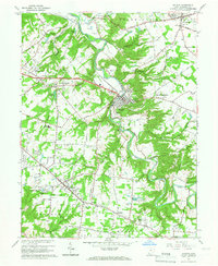
 1964 Louisville1964 Print · USGSThe Ohio River valley and Kentucky Bluegrass are captured in the mid-1960s, showing a region balanced between industrial growth and its agrarian roots. Genealogists and historians can trace the development of county seats like Shelbyville and Paris, or locate established institutions such as Georgetown College and Bernheim Forest.
 - 1965 Map of Batavia, 1967 Print
 1965 Batavia1967 Print · USGSClermont County in the mid-sixties shows the transition from rural townships to growing commuter hubs along the Norfolk and Western Railway. You can trace family history at the IOOF Cem or locate vanished landmarks like the Sky Hill Airport and the local Drive-in Theater.5 unique versions available
 - 1968 Map of Laurel, 1970 Print
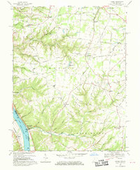 1968 Laurel1970 Print · USGSClermont County's riverfront and upland townships are captured here in the late sixties, showing a landscape defined by its deep runs and rural hubs. Researchers can trace historic family names and sites such as the Crane Schoolhouse, Point Pleasant, and the Laurel Cem.2 unique versions available
 - 1968 Map of Moscow, 1971 Print
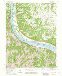 1968 Moscow1971 Print · USGSLife along the riverfront takes center stage in the late sixties as navigation and rail transport define this stretch of the Ohio valley. Researchers can trace family history through riverside towns and rural landmarks like Moscow Cem, the Chesapeake + Ohio railroad, and McKendree Cem Ch.2 unique versions available
End of results
Showing maps 1-4 of 4
Top cities near Monroe Township
- Cincinnati historical maps
- Fort Thomas historical maps
- Madeira historical maps
- Alexandria historical maps
- Milford historical maps
- Cold Spring historical maps
See more
Top neighborhoods of Monroe Township
- Clermontville historical maps
- Wiltsee historical maps
- Hulington historical maps
- Nicholsville historical maps
- Laurel historical maps
- Mount Holly historical maps
See more
Frequently asked questions
- What are the different types of historical maps available for Monroe Township?
- What is the oldest map of Monroe Township?
- Where can I purchase historical maps of Monroe Township for my home or office?
- Where can I download high-res historical maps of Monroe Township?
- Are there historical topographic maps available for Monroe Township?
- Is there historical aerial imagery available for Monroe Township?
- Where are historical maps of Monroe Township sourced from?