1990s Maps of Franklin Township, Ohio
Explore 2 historic maps of Franklin Township from the 1990s. These maps offer a rare glimpse into what life looked like during the 1990s — showing old roads, neighborhoods, homes, and landmarks that have changed or disappeared over time.
Whether you're researching your family's past, planning a metal detecting trip, or studying how Franklin Township's landscape evolved across the 1990s, these high-resolution maps are a powerful tool for exploring the history of this region.
- Focus on a specific era: All maps on this page are from the 1990s, giving you a focused view of this time period.
- See what’s changed: Compare century-old streets, trails, and buildings to today's modern landscape using overlays and satellite layers.
- Research with precision: Use these maps for genealogy, historical research, land use analysis, or educational projects.
- View, download, or print: Maps are fully viewable online in high resolution, and can be downloaded or printed for your own records.
Start exploring Franklin Township's history through authentic maps from the 1990s. This is your window into the past.
Franklin Township, OH maps
(2)- 1994 Map of Wills Creek, 1998 Print
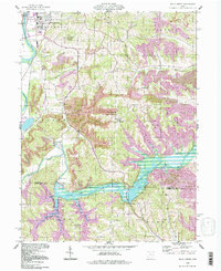 1994 Wills Creek1998 Print · USGSThe Wills Creek valley was a hub of mining and water management in the late twentieth century. Genealogists and local researchers can trace the roads to Marquand Mills, Our Lady of Lourdes Ch, and the Wills Creek Dam.
 - 1994 Map of Conesville, 1998 Print
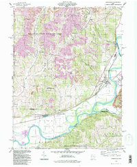 1994 Conesville1998 Print · USGSThe Muskingum River valley during the late twentieth century reveals a landscape shaped by coal extraction and river commerce. Researchers can locate numerous family burial grounds like Warner Ch Cem and rural settlements such as New Moscow or Adams Mills.
End of results
Showing maps 1-2 of 2
Top cities near Franklin Township
- Zanesville historical maps
- Coshocton historical maps
- New Concord historical maps
- West Lafayette historical maps
- Keene historical maps
- Dresden historical maps
See more
Top neighborhoods of Franklin Township
Frequently asked questions
- What are the different types of historical maps available for Franklin Township?
- What is the oldest map of Franklin Township?
- Where can I purchase historical maps of Franklin Township for my home or office?
- Where can I download high-res historical maps of Franklin Township?
- Are there historical topographic maps available for Franklin Township?
- Is there historical aerial imagery available for Franklin Township?
- Where are historical maps of Franklin Township sourced from?