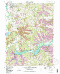
1994 Map of Wills Creek
USGS Topo · Published 1998About this map
The Muskingum River and the sprawling Wills Creek Lake dominate this eastern Ohio landscape, where the confluence of major waterways and intensive surface mining define the terrain. The reservoir, maintained at a normal pool elevation of 742 feet, is anchored by the Wills Creek Dam and surrounded by the Simco Wetlands State Wildlife Area. This era shows a complex industrial footprint of numerous strip mines and mines that weave between the ridges of Franklin and Linton townships.
Find a feature on this map
47 named features on this map. Tap any name to fly to it.
Don’t see what you’re looking for? This feature index may not catch every label — zoom into the map to look around manually.
Map Details
Editions of this 1994 Wills Creek Map
This is the sole edition of this map. No revisions or reprints were ever made.
Other maps of this area

1908 · Conesville
USGS Topo · 1:62,500

1909 · Cambridge
USGS Topo · 1:62,500

1910 · Conesville
USGS Topo · 1:62,500

1911 · Newcomerstown
USGS Topo · 1:62,500

1912 · Cambridge
USGS Topo · 1:62,500

1913 · Newcomerstown
USGS Topo · 1:62,500

1913 · Coshocton
USGS Topo · 1:62,500

1915 · Coshocton
USGS Topo · 1:62,500

1943 · Coshocton
USGS Topo · 1:62,500

1943 · Newcomerstown
USGS Topo · 1:62,500