1960s Maps of Jackson Township, Ohio
Explore 5 historic maps of Jackson Township from the 1960s. These maps offer a rare glimpse into what life looked like during the 1960s — showing old roads, neighborhoods, homes, and landmarks that have changed or disappeared over time.
Whether you're researching your family's past, planning a metal detecting trip, or studying how Jackson Township's landscape evolved across the 1960s, these high-resolution maps are a powerful tool for exploring the history of this region.
- Focus on a specific era: All maps on this page are from the 1960s, giving you a focused view of this time period.
- See what’s changed: Compare century-old streets, trails, and buildings to today's modern landscape using overlays and satellite layers.
- Research with precision: Use these maps for genealogy, historical research, land use analysis, or educational projects.
- View, download, or print: Maps are fully viewable online in high resolution, and can be downloaded or printed for your own records.
Start exploring Jackson Township's history through authentic maps from the 1960s. This is your window into the past.
Jackson Township, OH maps
(5)- 1961 Map of Coshocton, 1963 Print
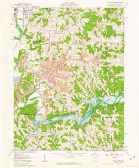
 1961 Coshocton1963 Print · USGSCoshocton and its surrounding river forks are captured here in the early sixties, showing the industrial and agricultural heart of the county. Genealogists and historians can trace the locations of Sacred Heart Ch, Oak Grove Cem, and the specialized U S Hydrologic Experiment Station.4 unique versions available
 - 1962 Map of Canton
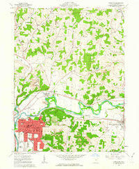
 1962 Canton1962 Print · USGSThe industrial heartland of Eastern Ohio and Western Pennsylvania thrives in the early sixties as steel mills and rail lines dominate the river valleys. Genealogists and historians can trace local landmarks like McKinley National Memorial, Malone College, and industrial sites such as Republic Steel Corp.2 unique versions available
 - 1962 Map of Randle, 1963 Print
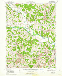 1962 Randle1963 Print · USGSCoshocton County in the early sixties shows a landscape of river-valley agriculture and growing energy extraction. Researchers can trace the old railroad grade, locate family sites near Antioch Cem, or find industrial roots at strip mines and Sixmile Dam.4 unique versions available
 - 1962 Map of Wills Creek, 1963 Print
 1962 Wills Creek1963 Print · USGSCoshocton and Muskingum counties are shown in the early 1960s as the regional economy shifted between river valley agriculture and heavy industrial mining. Researchers can trace rural life through Marquand Mills, the Wills Creek Dam, and numerous sites like Zion Ch Cem.4 unique versions available
 - 1962 Map of Conesville, 1963 Print
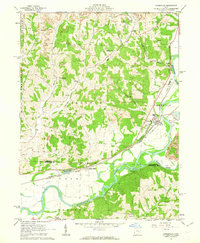 1962 Conesville1963 Print · USGSThe Muskingum River valley comes to life in this early 1960s survey, showing the intensive coal mining and rail activity of central Ohio. Genealogists can locate family landmarks like McGee Cem, Titus Cem, and the rural community at New Moscow.4 unique versions available
End of results
Showing maps 1-5 of 5
Top cities near Jackson Township
- Coshocton historical maps
- West Lafayette historical maps
- Keene historical maps
- Dresden historical maps
- Franklin historical maps
- Frazeysburg historical maps
See more
Top neighborhoods of Jackson Township
Frequently asked questions
- What are the different types of historical maps available for Jackson Township?
- What is the oldest map of Jackson Township?
- Where can I purchase historical maps of Jackson Township for my home or office?
- Where can I download high-res historical maps of Jackson Township?
- Are there historical topographic maps available for Jackson Township?
- Is there historical aerial imagery available for Jackson Township?
- Where are historical maps of Jackson Township sourced from?