1960s Maps of Bucyrus Township, Ohio
Explore 6 historic maps of Bucyrus Township from the 1960s. These maps offer a rare glimpse into what life looked like during the 1960s — showing old roads, neighborhoods, homes, and landmarks that have changed or disappeared over time.
Whether you're researching your family's past, planning a metal detecting trip, or studying how Bucyrus Township's landscape evolved across the 1960s, these high-resolution maps are a powerful tool for exploring the history of this region.
- Focus on a specific era: All maps on this page are from the 1960s, giving you a focused view of this time period.
- See what’s changed: Compare century-old streets, trails, and buildings to today's modern landscape using overlays and satellite layers.
- Research with precision: Use these maps for genealogy, historical research, land use analysis, or educational projects.
- View, download, or print: Maps are fully viewable online in high resolution, and can be downloaded or printed for your own records.
Start exploring Bucyrus Township's history through authentic maps from the 1960s. This is your window into the past.
Bucyrus Township, OH maps
(6)- 1960 Map of Oceola, 1961 Print
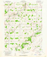 1960 Oceola1961 Print · USGSCrawford and Wyandot Counties are captured here in the early sixties, showing a landscape defined by geometric farm plots and historic treaty lines. Genealogists can locate family landmarks like Maple Grove Cem, Mt Zion Sch, and the riverside Camp Michael.3 unique versions available
 - 1960 Map of Bucyrus, 1962 Print
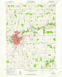 1960 Bucyrus1962 Print · USGSBucyrus flourished as a vital rail and civic crossroads during the early sixties, surrounded by the productive farmsteads of Crawford County. Genealogists and local researchers can trace historic burials at Oakwood Cemetery and Sixteen Cem or locate the old Seccaium Park.4 unique versions available
 - 1961 Map of Caledonia, 1962 Print
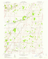
 1961 Caledonia1962 Print · USGSAgricultural life in Marion and Crawford counties is captured here in the early sixties, as rail lines still linked small rural hubs. Trace family history through Monnett Chapel, Rush Cem, and the rail junction at Caledonia.2 unique versions available
 - 1961 Map of Monnett, 1963 Print
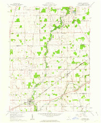
 1961 Monnett1963 Print · USGSMarion and Crawford counties appear here in the early 1960s, showing a landscape defined by historical treaty lines and vital rail corridors. Researchers can locate family landmarks like Likens Cem and Kirkpatrick Cem, or trace the tracks of the Pennsylvania railroad through Monnett.2 unique versions available
 - 1962 Map of Marion
 1962 Marion1962 Print · USGSCentral Ohio during the post-war era showcases a dense network of railroad towns and emerging interstate highways. Genealogists can trace family roots in smaller settlements like Houcktown and Marseilles or locate landmarks near Indian Lake.
 - 1966 Map of Marion, 1968 Print
 1966 Marion1968 Print · USGSCentral Ohio in the mid-sixties is captured during a period of rapid highway expansion and industrial connectivity. Genealogists and historians can trace rail-and-river networks through towns like Marion, Urbana, and Mount Vernon, or locate landmarks such as Malabar Farm and Black Hand Rock.3 unique versions available
End of results
Showing maps 1-6 of 6
Top cities near Bucyrus Township
- Marion historical maps
- Bucyrus historical maps
- Galion historical maps
- Upper Sandusky historical maps
- Mount Gilead historical maps
- Claridon historical maps
See more
Frequently asked questions
- What are the different types of historical maps available for Bucyrus Township?
- What is the oldest map of Bucyrus Township?
- Where can I purchase historical maps of Bucyrus Township for my home or office?
- Where can I download high-res historical maps of Bucyrus Township?
- Are there historical topographic maps available for Bucyrus Township?
- Is there historical aerial imagery available for Bucyrus Township?
- Where are historical maps of Bucyrus Township sourced from?