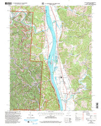
2000-2009 Maps of Gallia County, Ohio
Explore 8 historic maps of Gallia County from 2000-2009. These maps offer a rare glimpse into what life looked like during the 2000s — showing old roads, neighborhoods, homes, and landmarks that have changed or disappeared over time.
Whether you're researching your family's past, planning a metal detecting trip, or studying how Gallia County's landscape evolved across the 2000s, these high-resolution maps are a powerful tool for exploring the history of this region.
- Focus on a specific era: All maps on this page are from the 2000s, giving you a focused view of this time period.
- See what’s changed: Compare century-old streets, trails, and buildings to today's modern landscape using overlays and satellite layers.
- Research with precision: Use these maps for genealogy, historical research, land use analysis, or educational projects.
- View, download, or print: Maps are fully viewable online in high resolution, and can be downloaded or printed for your own records.
Start exploring Gallia County's history through authentic maps from the 2000s. This is your window into the past.
Gallia County, OH maps
(8)- 2002 Map of Rodney, 2006 Print
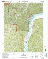
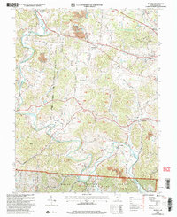 2002 Rodney2006 Print · USGSGallia County at the turn of the millennium shows a landscape where public lands and industry meet along the bends of Raccoon Creek. Genealogists can locate family sites like the Hulbert Cem, Alexander Ch, and the old Green Sch.
 - 2002 Map of Glenwood, 2006 Print
 2002 Glenwood2006 Print · USGSThe Ohio River valley and the ridges of Cabell and Mason counties are shown here as they appeared at the start of the century. Genealogists and local historians can trace rural family life through landmarks like Moores Chapel, Swan Creek Sch, and Dudley Gap.
 - 2002 Map of Apple Grove, 2006 Print
 2002 Apple Grove2006 Print · USGSLife along the Ohio River at the dawn of the 21st century centered on riverfront hamlets and the ridges of the Wayne National Forest. Researchers can trace local heritage through sites like Mercers Bottom, Sunnyside School, and several family-linked cemeteries like Kings Chapel.
 - 2002 Map of Waterloo, 2006 Print
 2002 Waterloo2006 Print · USGSThe rugged ridges of Lawrence and Gallia counties are seen here in the early 2000s within the Wayne National Forest. Genealogists can trace family names through Waterloo Cem and find early community hubs like Flag Spring Ch and Arabia.
 - 2002 Map of Athalia, 2006 Print
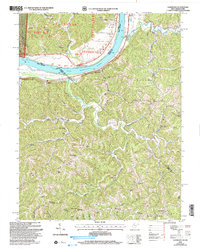
 2002 Athalia2006 Print · USGSThe Ohio River valley at the start of the 21st century reveals a landscape of riverside villages and upland forest reserves. Genealogists and historians can trace community roots through numerous country churches like Wilma Chapel and old schools including Fairland Sch No 3.
 - 2002 Map of Patriot, 2006 Print
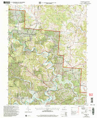 2002 Patriot2006 Print · USGSGallia County at the turn of the millennium shows a landscape defined by the winding waters of Symmes Creek and the wooded reaches of the Wayne National Forest. Researchers can trace old family sites and rural landmarks like the McDaniel Cem, Siloam Cem, and the village of Patriot.
 - 2002 Map of Mercerville, 2006 Print
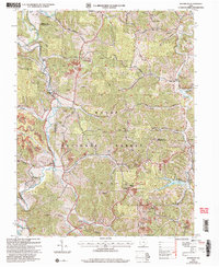
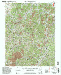 2002 Mercerville2006 Print · USGSGallia County at the turn of the millennium shows a rural landscape transitioning from industrial extraction to conservation within the Wayne National Forest. Researchers can locate decades of local history at Mercerville, tracing family roots through Ridgelawn Cem, White Ch Cem, and the Hannah-Trace High Sch.
 - 2002 Map of Gallia, 2006 Print
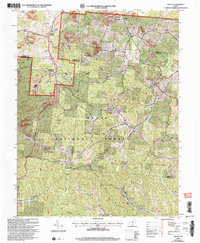 2002 Gallia2006 Print · USGSSouthern Ohio's industrial and forest lands are captured here at the turn of the century as the coal and clay heritage meets the growing woods. Genealogists can trace family landmarks like Washington Cem, Jefferson Sch, and the old settlement of Pokepatch.
End of results
Showing maps 1-8 of 8
Top cities of Gallia County
- Gallipolis historical maps
- Rio Grande historical maps
- Crown City historical maps
- Vinton historical maps
- Cheshire historical maps
Frequently asked questions
- What are the different types of historical maps available for Gallia County?
- What is the oldest map of Gallia County?
- Where can I purchase historical maps of Gallia County for my home or office?
- Where can I download high-res historical maps of Gallia County?
- Are there historical topographic maps available for Gallia County?
- Is there historical aerial imagery available for Gallia County?
- Where are historical maps of Gallia County sourced from?