1950s Maps of Gallia County, Ohio
Explore 6 historic maps of Gallia County from the 1950s. These maps offer a rare glimpse into what life looked like during the 1950s — showing old roads, neighborhoods, homes, and landmarks that have changed or disappeared over time.
Whether you're researching your family's past, planning a metal detecting trip, or studying how Gallia County's landscape evolved across the 1950s, these high-resolution maps are a powerful tool for exploring the history of this region.
- Focus on a specific era: All maps on this page are from the 1950s, giving you a focused view of this time period.
- See what’s changed: Compare century-old streets, trails, and buildings to today's modern landscape using overlays and satellite layers.
- Research with precision: Use these maps for genealogy, historical research, land use analysis, or educational projects.
- View, download, or print: Maps are fully viewable online in high resolution, and can be downloaded or printed for your own records.
Start exploring Gallia County's history through authentic maps from the 1950s. This is your window into the past.
Gallia County, OH maps
(6)- 1957 Map of Huntington, 1966 Print
 1957 Huntington1966 Print · USGSThe industrial heart of the Ohio River valley is captured here in the mid-sixties, showing the growth of Huntington and Ashland. Researchers can trace the extensive rail networks of the Chesapeake and Ohio RR and locate sites like the Chief Cornstalk Hunting Ground.3 unique versions available
 - 1958 Map of Glenwood, 1959 Print
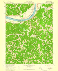 1958 Glenwood1959 Print · USGSThe Ohio River valley in the late fifties was a landscape of ridge-top schools and river-rail commerce. Genealogists can trace family names at Swan Creek Ch, Barker Sch, and Bias Chapel.2 unique versions available
 - 1958 Map of Athalia, 1959 Print
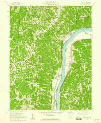 1958 Athalia1959 Print · USGSThe Ohio River valley and the surrounding Lawrence County hill country are captured here in the late fifties. Researchers can trace the riverfront rail economy along the Baltimore and Ohio and locate landmarks like Fairland Sch No 4 and Caldwell Cem.
 - 1958 Map of Cheshire, 1959 Print
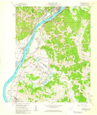 1958 Cheshire1959 Print · USGSThe Ohio River valley near Point Pleasant hummed with mid-century industry and institutional growth along the rail lines. Researchers can trace the footprints of the Lakin State Hospital, the Clifton F McClintic State Wildlife Station, and numerous local landmarks like Spillman Ch.
 - 1958 Map of Gallipolis, 1960 Print
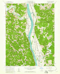
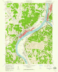 1958 Gallipolis1960 Print · USGSThe confluence of the Ohio and Kanawha Rivers comes alive in the late 1950s, showing the vital border connection between Ohio and West Virginia. Genealogists and local historians can trace family sites from Mound Hill Cemetery to rural landmarks like Mina Chapel and the County Childrens Home.4 unique versions available
 - 1958 Map of Apple Grove, 1961 Print
 1958 Apple Grove1961 Print · USGSThe Ohio River valley south of Point Pleasant was a landscape of river-and-rail industry and small farming hamlets in the late fifties. Genealogists and historians can trace family roots through landmarks like Mercers Bottom, the Clay Chapel Cem, and Beale Chapel.2 unique versions available
End of results
Showing maps 1-6 of 6
Top cities of Gallia County
- Gallipolis historical maps
- Rio Grande historical maps
- Crown City historical maps
- Vinton historical maps
- Cheshire historical maps
Frequently asked questions
- What are the different types of historical maps available for Gallia County?
- What is the oldest map of Gallia County?
- Where can I purchase historical maps of Gallia County for my home or office?
- Where can I download high-res historical maps of Gallia County?
- Are there historical topographic maps available for Gallia County?
- Is there historical aerial imagery available for Gallia County?
- Where are historical maps of Gallia County sourced from?