1900-1909 Maps of Geauga County, Ohio
Explore 8 historic maps of Geauga County from 1900-1909. These maps offer a rare glimpse into what life looked like during the 1900s — showing old roads, neighborhoods, homes, and landmarks that have changed or disappeared over time.
Whether you're researching your family's past, planning a metal detecting trip, or studying how Geauga County's landscape evolved across the 1900s, these high-resolution maps are a powerful tool for exploring the history of this region.
- Focus on a specific era: All maps on this page are from the 1900s, giving you a focused view of this time period.
- See what’s changed: Compare century-old streets, trails, and buildings to today's modern landscape using overlays and satellite layers.
- Research with precision: Use these maps for genealogy, historical research, land use analysis, or educational projects.
- View, download, or print: Maps are fully viewable online in high resolution, and can be downloaded or printed for your own records.
Start exploring Geauga County's history through authentic maps from the 1900s. This is your window into the past.
Geauga County, OH maps
(8)- 1904 Map of Chardon, 1962 Print
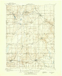
 1904 Chardon1962 Print · USGSGeauga and Lake Counties are shown here during the early twentieth century, just as the region's electric and steam rail networks were at their peak. Researchers can trace the routes of the Cleveland and Chardon Electric RR and find local landmarks like Indian Point or the Infirmary.
 - 1905 Map of Garrettsville, 1958 Print
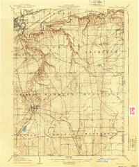
 1905 Garrettsville1958 Print · USGSNortheastern Ohio is shown here at the start of the twentieth century, during a period of heavy rail and traction expansion across Geauga and Portage counties. Genealogists can trace early homesteads near Hiram Rapids, Nelson, and family-named landmarks like Newels Ledge or Steele Crossing.
 - 1905 Map of Mentor, 1961 Print
 1905 Mentor1961 Print · USGSLake County and Geauga County thrived in the early twentieth century as a hub for electric rail travel and river-powered industry. Genealogists and historians can trace the foundations of Willoughby and Painesville or locate early milling sites like Wilson Mills and Fowlers Mill.
 - 1906 Map of Chardon, 1940 Print
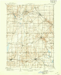
 1906 Chardon1940 Print · USGSGeauga and Lake Counties are mapped here during the era of steam and electric rail, showing the landscape between Chardon and Painesville. Researchers can trace old township boundaries and find landmarks like the Infirmary, Bass Lake, and the New York Chicago and St Louis RR.2 unique versions available
 - 1906 Map of Chagrin Falls, 1955 Print
 1906 Chagrin Falls1955 Print · USGSThe Western Reserve landscape of Northeast Ohio is captured here during a period of rapid transit growth and settlement. Researchers can trace early township hubs and rail stops like Falls Junction Glenwillow PO, Orange Hill Church, and the winding Cleveland and Garrettsville Electric RR.
 - 1907 Map of Garrettsville, 1943 Print
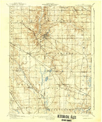
 1907 Garrettsville1943 Print · USGSThe Western Reserve landscape of the early 1900s comes alive in this survey of Geauga and Portage counties. Trace the vanished routes of the Eastern Ohio Traction line or locate family-named settlements like Bundysburg and Smith Crossing.2 unique versions available
 - 1907 Map of Mentor, 1947 Print
 1907 Mentor1947 Print · USGSNortheast Ohio thrives at the turn of the century, where the electric railway and steam lines meet the Lake Erie shore. Genealogists can trace early homesteads near Eagles Mill, Richmond Grand River PO, and the old postal stop at Mulberry Corners.
 - 1908 Map of Chagrin Falls, 1939 Print
 1908 Chagrin Falls1939 Print · USGSThe Chagrin Valley at the turn of the century was a crossroads of electric interurban lines and early rural post offices. Trace the old rail stops at Aurora Station and Cannons Crossing, or locate family landmarks like Orange Hill Church.2 unique versions available
End of results
Showing maps 1-8 of 8
Top cities of Geauga County
- Chardon historical maps
- Hambden Township historical maps
- South Russell historical maps
- Bainbridge Township historical maps
- Burton Township historical maps
Frequently asked questions
- What are the different types of historical maps available for Geauga County?
- What is the oldest map of Geauga County?
- Where can I purchase historical maps of Geauga County for my home or office?
- Where can I download high-res historical maps of Geauga County?
- Are there historical topographic maps available for Geauga County?
- Is there historical aerial imagery available for Geauga County?
- Where are historical maps of Geauga County sourced from?