1960s Maps of Guernsey County, Ohio
Explore 20 historic maps of Guernsey County from the 1960s. These maps offer a rare glimpse into what life looked like during the 1960s — showing old roads, neighborhoods, homes, and landmarks that have changed or disappeared over time.
Whether you're researching your family's past, planning a metal detecting trip, or studying how Guernsey County's landscape evolved across the 1960s, these high-resolution maps are a powerful tool for exploring the history of this region.
- Focus on a specific era: All maps on this page are from the 1960s, giving you a focused view of this time period.
- See what’s changed: Compare century-old streets, trails, and buildings to today's modern landscape using overlays and satellite layers.
- Research with precision: Use these maps for genealogy, historical research, land use analysis, or educational projects.
- View, download, or print: Maps are fully viewable online in high resolution, and can be downloaded or printed for your own records.
Start exploring Guernsey County's history through authentic maps from the 1960s. This is your window into the past.
Guernsey County, OH maps
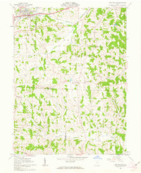
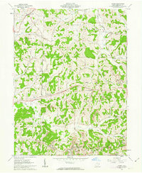
(20)- 1961 Map of Clarksburg
 1961 Clarksburg1961 Print · USGSThe mid-century industrial and river landscapes of West Virginia and Ohio are detailed here, centered on the Ohio River. Researchers can trace the Baltimore and Ohio rail lines connecting towns like Parkersburg, Clarksburg, and Monongah.
 - 1961 Map of Piedmont, 1962 Print
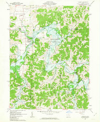
 1961 Piedmont1962 Print · USGSHarrison and Belmont counties in the early sixties show a landscape transformed by the Muskingum Watershed Conservancy District. Genealogists and historians can locate the Quaker Cem, trace the Baltimore and Ohio rail lines, and find early coal Strip Mines.4 unique versions available
 - 1961 Map of Fairview, 1962 Print
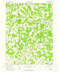
 1961 Fairview1962 Print · USGSThe Guernsey and Belmont county border area was undergoing significant change in the 1960s as highway expansion met traditional coal mining. Researchers can trace family history through Salem Ch and Gibson Cem or locate industrial sites like the Strip Mines and Bradfield Airport.3 unique versions available
 - 1961 Map of Byesville, 1963 Print
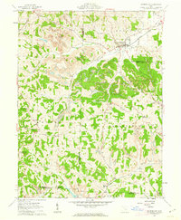
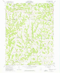
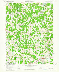
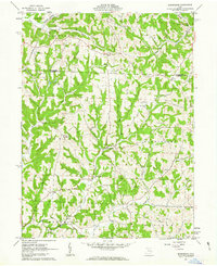
 1961 Byesville1963 Print · USGSGuernsey County's mining and rail landscape is captured here in the early sixties, showing the transition between historic military districts and congress lands. Genealogists can locate family sites at Greenwood Cemetery, Beech Grove Sch, and along the Old Railroad Grade.4 unique versions available
 - 1961 Map of Barnesville, 1963 Print
 1961 Barnesville1963 Print · USGSThe hilltop town of Barnesville thrived in the early sixties as a center for industry and education in eastern Ohio. Researchers can trace family history through the Old Quaker Cemetery, find the Friends School, or locate rural outposts like Baileys Mills and Somerton.3 unique versions available
 - 1961 Map of Cumberland, 1963 Print
 1961 Cumberland1963 Print · USGSSoutheastern Ohio's hill country is captured here during the early sixties, showing a landscape defined by rail transport and surface mining. Trace the Baltimore and Ohio tracks through Cumberland or locate family sites like Brookfield Cem and Ark Springs Ch.4 unique versions available
 - 1961 Map of Quaker City, 1963 Print
 1961 Quaker City1963 Print · USGSQuaker City and the rolling hills of Guernsey County were centers of rail and coal activity in the early sixties. Genealogists can trace family names through landmarks like the Richland Meetinghouse, Sand Hill Cem, and the village of Batesville.2 unique versions available
 - 1961 Map of Senecaville, 1963 Print
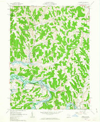
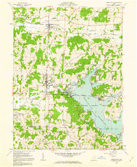 1961 Senecaville1963 Print · USGSSoutheast Ohio in the early sixties was a landscape of watershed engineering and coal mining. Researchers can trace the Baltimore and Ohio rail line through Lore City or locate family plots at St Patricks Cem and Weaver Cem.3 unique versions available
 - 1961 Map of Caldwell North, 1963 Print
 1961 Caldwell North1963 Print · USGSCentral Noble County in the early sixties reveals a landscape of coal-hauling rail lines and creek-bottom settlements. Genealogists can trace family landmarks like McElroy Cemetery, the community at Hiramsburg, and rural landmarks such as Clarks Chapel.3 unique versions available
 - 1961 Map of New Concord, 1963 Print
 1961 New Concord1963 Print · USGSMuskingum County and the village of New Concord are captured in the early sixties as local industry and campus life expanded. Researchers can trace family roots at Zion Cem or locate former rural landmarks like the Westland Sch and Rix Mills.4 unique versions available
 - 1961 Map of Freeport, 1963 Print
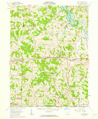
 1961 Freeport1963 Print · USGSHarrison and Guernsey counties are shown here in the early sixties, a landscape of ridge-top farms and narrow creek valleys. Trace the Baltimore and Ohio rail line or locate ancestral sites like Scotch Covenanter Cem and Pleasant Hill Ch.3 unique versions available
 - 1961 Map of Birmingham, 1976 Print
 1961 Birmingham1976 Print · USGSThe rural hills of Guernsey County come alive in the early sixties, showing a landscape of small farming communities and country parishes. Genealogists can trace family names through local sites like Irish Ridge Ch, Cumberland Cem, and the old Salem-Washington Sch.3 unique versions available
 - 1962 Map of Canton
 1962 Canton1962 Print · USGSThe industrial heartland of Eastern Ohio and Western Pennsylvania thrives in the early sixties as steel mills and rail lines dominate the river valleys. Genealogists and historians can trace local landmarks like McKinley National Memorial, Malone College, and industrial sites such as Republic Steel Corp.2 unique versions available
 - 1962 Map of Old Washington, 1963 Print
 1962 Old Washington1963 Print · USGSGuernsey County's rural landscape is captured here in the early sixties, as a massive PROPOSED highway begins to redraw the local geography. Researchers can find long-standing community landmarks like the Fairground, Winterset Cem, and the village of Old Washington.3 unique versions available
 - 1962 Map of Plainfield, 1963 Print
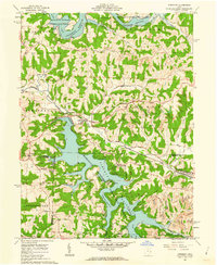
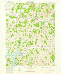
 1962 Plainfield1963 Print · USGSCoshocton and Guernsey counties are shown here in the early 1960s as the Wills Creek Reservoir reshaped the valley. Genealogists and local historians can trace small settlements like Linton Mills and Birds Run alongside numerous family cemeteries.4 unique versions available
 - 1962 Map of Bloomfield, 1963 Print
 1962 Bloomfield1963 Print · USGSEastern Ohio’s ridgelines and creek valleys are captured here in the early sixties, showing the expansion of New Concord and the local energy economy. Researchers can locate family landmarks like Hawthorne Cem, the Ford Cem, and the historic Lebanon Ch.4 unique versions available
 - 1962 Map of Kimbolton, 1963 Print
 1962 Kimbolton1963 Print · USGSGuernsey County's rolling hills and the Wills Creek valley are captured in the early sixties, showing the landscape before modern development. Genealogists can trace family names through rural landmarks like Kimbolton Cem, Wheeling Sch, and the remote settlement of Postboy.3 unique versions available
 - 1962 Map of Cambridge, 1963 Print
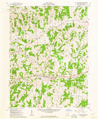
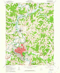 1962 Cambridge1963 Print · USGSMid-century Cambridge is a thriving rail and industrial center where the Baltimore and Ohio and Pennsylvania lines meet. Genealogists and historians can trace neighborhood growth through local landmarks like Lincoln Sch, the Cambridge State Hospital, and Northwood Cemetery.3 unique versions available
 - 1962 Map of Antrim, 1963 Print
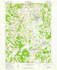
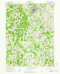
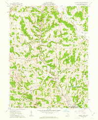
 1962 Antrim1963 Print · USGSGuernsey County in the early sixties reveals a landscape shaped by historical land grants and emerging industry. Genealogists can locate family sites near Salt Fork Ch, McCoy Ch Cem, or the old Oxford Township Sch.2 unique versions available
 - 1963 Map of Birmingham
 1963 Birmingham1963 Print · USGSGuernsey County and the Tuscarawas border are captured here in the early 1960s, showing a landscape of upland ridges and deep creek forks. Genealogists and historians can trace rural sites like Cumberland Cem, Irish Ridge Ch, and the small settlement of Birmingham.
End of results
Showing maps 1-20 of 20
Top cities of Guernsey County
- Cambridge historical maps
- Byesville historical maps
- Center historical maps
- Londonderry historical maps
- Quaker City historical maps
- Senecaville historical maps
See more
Frequently asked questions
- What are the different types of historical maps available for Guernsey County?
- What is the oldest map of Guernsey County?
- Where can I purchase historical maps of Guernsey County for my home or office?
- Where can I download high-res historical maps of Guernsey County?
- Are there historical topographic maps available for Guernsey County?
- Is there historical aerial imagery available for Guernsey County?
- Where are historical maps of Guernsey County sourced from?