1990s Maps of Guernsey County, Ohio
Explore 22 historic maps of Guernsey County from the 1990s. These maps offer a rare glimpse into what life looked like during the 1990s — showing old roads, neighborhoods, homes, and landmarks that have changed or disappeared over time.
Whether you're researching your family's past, planning a metal detecting trip, or studying how Guernsey County's landscape evolved across the 1990s, these high-resolution maps are a powerful tool for exploring the history of this region.
- Focus on a specific era: All maps on this page are from the 1990s, giving you a focused view of this time period.
- See what’s changed: Compare century-old streets, trails, and buildings to today's modern landscape using overlays and satellite layers.
- Research with precision: Use these maps for genealogy, historical research, land use analysis, or educational projects.
- View, download, or print: Maps are fully viewable online in high resolution, and can be downloaded or printed for your own records.
Start exploring Guernsey County's history through authentic maps from the 1990s. This is your window into the past.
Guernsey County, OH maps
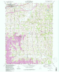
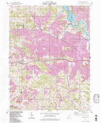
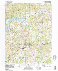
(22)- 1993 Map of Old Washington
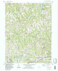
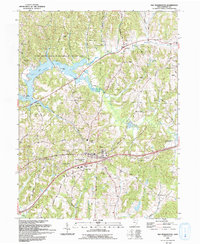 1993 Old Washington1993 Print · USGSGuernsey County's rolling hills are shown in the early nineties, centered on the village of Old Washington and the newly developed corridors of Interstate 70. Genealogists and local historians can trace rural family sites near Winterset Cem, Madison Sch, and the old Zane Road.
 - 1993 Map of Bloomfield
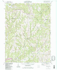
 1993 Bloomfield1993 Print · USGSGuernsey County's rural landscape is captured here in the early nineties, showing a region defined by winding creek valleys and hilltop settlements. Researchers can trace family history through sites like Indian Camp, Northfield Cem, and the Mt Harmon Ch near the banks of Wills Creek Lake.
 - 1993 Map of Antrim
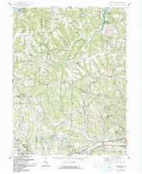
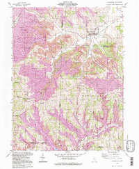
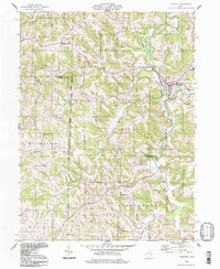
 1993 Antrim1993 Print · USGSGuernsey County in the early nineties remains a landscape of ridge-top roads and creek-bottom settlements. Researchers can trace the United States Military District Boundary or find local landmarks like McCoy Ch Cem and the Mennonite Ch.
 - 1993 Map of Plainfield
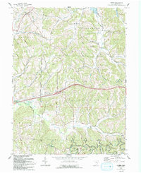
 1993 Plainfield1993 Print · USGSThe eastern Ohio borderlands of Coshocton and Guernsey counties appear here in the early nineties, centered on the complex shoreline of Wills Creek Lake. Researchers can locate several burial grounds like Schweitzer Cem and trace the paths of the Old RR Gr through Birds Run.
 - 1993 Map of Cambridge, 1994 Print
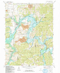
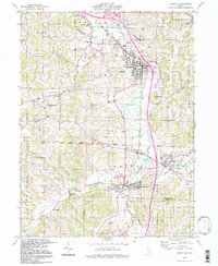
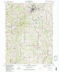
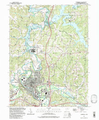
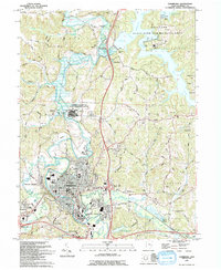 1993 Cambridge1994 Print · USGSThe city of Cambridge and the massive Salt Fork Lake reservoir define this Guernsey County landscape in the early nineties. Researchers can trace local genealogy through Northwood Cemetery and St Lukes Chapel or locate old industrial sites like Mineral Siding.
 - 1994 Map of Kimbolton
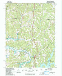 1994 Kimbolton1994 Print · USGSThe Guernsey County countryside at the close of the twentieth century shows a landscape transitioning between rural heritage and public recreation. Genealogists can trace family landmarks at Jones Cem, Kimbolton Cem, and the old Liberty Sch.2 unique versions available
 - 1994 Map of Plainfield, 1998 Print
 1994 Plainfield1998 Print · USGSEastern Ohio's river valleys and coal-rich hills are shown here in the 1990s as Wills Creek winds through the meeting point of three counties. Researchers can trace rural lineages through numerous local sites including Linton Mills, Plainfield Cem, and Birds Run.
 - 1994 Map of Quaker City, 1998 Print
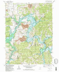
 1994 Quaker City1998 Print · USGSEastern Ohio hill country in the mid-nineties shows a landscape defined by pioneer survey lines and mineral extraction. Trace family sites near Salesville, Batesville, and the Richland Meetinghouse or follow the waters of Senecaville Lake.
 - 1994 Map of New Concord, 1998 Print
 1994 New Concord1998 Print · USGSMuskingum and Guernsey counties are captured here in the mid-1990s, showcasing the intersection of academic life and heavy industry. Researchers can trace the Baltimore and Ohio rail corridor or locate landmarks like Muskingum College and Rix Mills.
 - 1994 Map of Piedmont, 1998 Print
 1994 Piedmont1998 Print · USGSEastern Ohio’s lake-filled landscapes and mining history are recorded here in the 1990s as reclamation efforts transformed the terrain. Genealogists can trace family sites at Belmont Ridge Cem or Quaker Cem and explore settlements like Piedmont and Holloway.
 - 1994 Map of Cumberland, 1998 Print
 1994 Cumberland1998 Print · USGSSoutheastern Ohio's hill country is captured here during the 1990s as it transitioned through large-scale land reclamation. Genealogists and local historians can trace family locations near Young Hickory, Cumberland, and rural landmarks like Mt Zion Cem or the Township Sch.
 - 1994 Map of Byesville, 1998 Print
 1994 Byesville1998 Print · USGSByesville and Pleasant City appear here in the mid-1990s, surrounded by an active landscape of extraction and deep-rooted community ties. Researchers can trace family history through sites like Greenwood Cemetery, Beech Grove Sch, and the Old Railroad Grade.
 - 1994 Map of Fairview, 1998 Print
 1994 Fairview1998 Print · USGSThe Guernsey and Belmont county line in the mid-nineties shows a landscape of recovery, where industrial reclamation meets vast conservation lands. Genealogists and historians can trace old homesteads near Fairview Cem, the rural crossroads of Sewellsville, and the Baltimore and Ohio line.
 - 1994 Map of Barnesville, 1998 Print
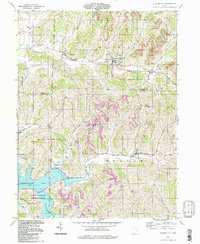
 1994 Barnesville1998 Print · USGSBelmont County in the late twentieth century reveals a transition from traditional agriculture to a landscape of mining and rural industry. Genealogists can locate family names and burial sites at Old Quaker Cem, while historians can trace community growth through Olney Sch and the Howell Airport.
 - 1994 Map of Caldwell North, 1998 Print
 1994 Caldwell North1998 Print · USGSSoutheast Ohio’s rural and industrial character is preserved here in the late twentieth century, before further changes altered the landscape. Researchers can trace old family sites and mining operations near Belle Valley, Hoskinsville, and the McElroy Cem.
 - 1994 Map of Senecaville, 1998 Print
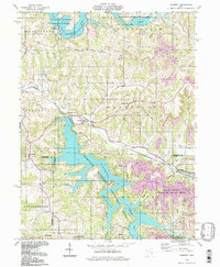
 1994 Senecaville1998 Print · USGSSoutheastern Ohio's Guernsey and Noble counties appear here during the late twentieth century, centered on the waters of Senecaville Lake. Researchers can trace the Baltimore and Ohio rail line or locate rural landmarks like Kings Mine and St Patricks Cem.
 - 1994 Map of Cambridge, 1998 Print
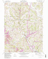
 1994 Cambridge1998 Print · USGSCambridge and its surrounding Guernsey County townships are shown here during a period of industrial and recreational expansion. Genealogists can trace family names through landmarks like Northwood Cem, St. Lukes Chapel, and the vanished Mineral Siding rail stop.
 - 1994 Map of Bloomfield, 1998 Print
 1994 Bloomfield1998 Print · USGSGuernsey and Muskingum counties are shown here in the 1990s, captured just before the turn of the century. You can trace family roots at Northfield Cem, locate the Indian Camp Covered Bridge, or find old schools like Pike Sch.
 - 1994 Map of Birmingham, 1998 Print
 1994 Birmingham1998 Print · USGSThe hills of Guernsey and Tuscarawas counties are captured here in the late twentieth century, showing a landscape of small crossroads and creek valleys. Genealogists can locate family landmarks like Cumberland Cem, Wesley Ch, and the old Salem-Washington Sch.
 - 1994 Map of Freeport, 1998 Print
 1994 Freeport1998 Print · USGSThe hill country where Harrison and Guernsey Counties meet is captured here in the 1990s, centered on the historic village of Freeport. Genealogists can trace family landmarks like the Scotch Covenanter Cem, Chestnut Hill Ch, and Londonderry Sch.
 - 1994 Map of Old Washington, 1998 Print
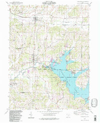
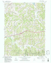
 1994 Old Washington1998 Print · USGSThe Guernsey County hills in the 1990s show a landscape of public recreation and rural industry near Old Washington. Researchers can trace old family lines through Winterset Cem, find the Brothers Aviation Landing Strip, or locate several Drill Hole sites.
 - 1994 Map of Antrim, 1998 Print
 1994 Antrim1998 Print · USGSGuernsey County's rural townships are shown in the 1990s as the landscape transitions from old survey boundaries to modern infrastructure. Researchers can locate ancestral landmarks like the Bond Cem, Salt Fork Ch, and the intersection of the Old Seven Ranges.
End of results
Showing maps 1-22 of 22
Top cities of Guernsey County
- Cambridge historical maps
- Byesville historical maps
- Center historical maps
- Londonderry historical maps
- Quaker City historical maps
- Senecaville historical maps
See more
Frequently asked questions
- What are the different types of historical maps available for Guernsey County?
- What is the oldest map of Guernsey County?
- Where can I purchase historical maps of Guernsey County for my home or office?
- Where can I download high-res historical maps of Guernsey County?
- Are there historical topographic maps available for Guernsey County?
- Is there historical aerial imagery available for Guernsey County?
- Where are historical maps of Guernsey County sourced from?