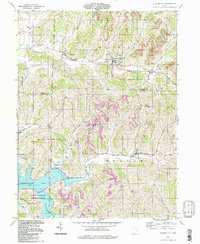
1994 Map of Quaker City
USGS Topo · Published 1998About this map
Quaker City sits at the heart of this landscape where the old boundary lines of the early American frontier still define the terrain. The map meticulously documents the transition from the West Boundary Old Seven Ranges to the East Boundary Congress Lands, a surveying legacy that influenced decades of land ownership. In the southern portion of the quadrangle, the Muskingum Watershed Conservancy District manages the waters of Senecaville Lake, where the Seneca Fork Wills Cr meets the reservoir. Smaller communities such as Salesville and Batesville are scattered across the hills, connected by a network of winding roads and the valley of Leatherwood Creek. The presence of numerous Oil Wells and a Strip Mine suggests an economy long tied to extraction, while several country churches like Richland Meetinghouse and Wesley Chapel mark the centers of rural social life.
Find a feature on this map
42 named features on this map. Tap any name to fly to it.
Don’t see what you’re looking for? This feature index may not catch every label — zoom into the map to look around manually.
Map Details
Editions of this 1994 Quaker City Map
This is the sole edition of this map. No revisions or reprints were ever made.
Other maps of this area

1903 · Flushing
USGS Topo · 1:62,500

1905 · Woodsfield
USGS Topo · 1:62,500

1905 · Flushing
USGS Topo · 1:62,500

1909 · Antrim
USGS Topo · 1:48,000

1909 · Summerfield
USGS Topo · 1:62,500

1911 · Antrim
USGS Topo · 1:62,500

1911 · Summerfield
USGS Topo · 1:62,500

1949 · Clarksburg
USGS Topo · 1:250,000

1951 · Canton
USGS Topo · 1:250,000

1953 · Canton
USGS Topo · 1:250,000