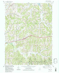
1994 Map of Antrim
USGS Topo · Published 1998About this map
The United States Military District Boundary and the Old Seven Ranges line intersect in this portion of Guernsey County, reflecting the complex early land survey history of eastern Ohio. The landscape is defined by the winding drainages of Salt Fork, Millers Fork, and Skull Fork, where the terrain rises to prominent ridges like the Hogback. Small rural communities such as Antrim and Middlebourne serve as anchors for a network of country roads named for local families and landmarks, including McCoy Road and Putney Ridge Road. For genealogists, the map identifies several local congregations and burial grounds, including the Methodist Ch, Pisgah Ch, Bond Cem, and Fletcher Cem. The presence of numerous Drill Hole sites and the Radio Tower (WOUC-TV) provides a look at the industrial and utility infrastructure supporting the region during the late twentieth century.
Find a feature on this map
47 named features on this map. Tap any name to fly to it.
Don’t see what you’re looking for? This feature index may not catch every label — zoom into the map to look around manually.
Map Details
Editions of this 1994 Antrim Map
This is the sole edition of this map. No revisions or reprints were ever made.
Other maps of this area

1903 · Flushing
USGS Topo · 1:62,500

1905 · Woodsfield
USGS Topo · 1:62,500

1905 · Flushing
USGS Topo · 1:62,500

1909 · Antrim
USGS Topo · 1:48,000

1909 · Summerfield
USGS Topo · 1:62,500

1911 · Antrim
USGS Topo · 1:62,500

1911 · Summerfield
USGS Topo · 1:62,500

1949 · Clarksburg
USGS Topo · 1:250,000

1951 · Canton
USGS Topo · 1:250,000

1953 · Canton
USGS Topo · 1:250,000